USA TRAVEL GUIDE
Seattle Skyline Photography from Queen Anne Hill
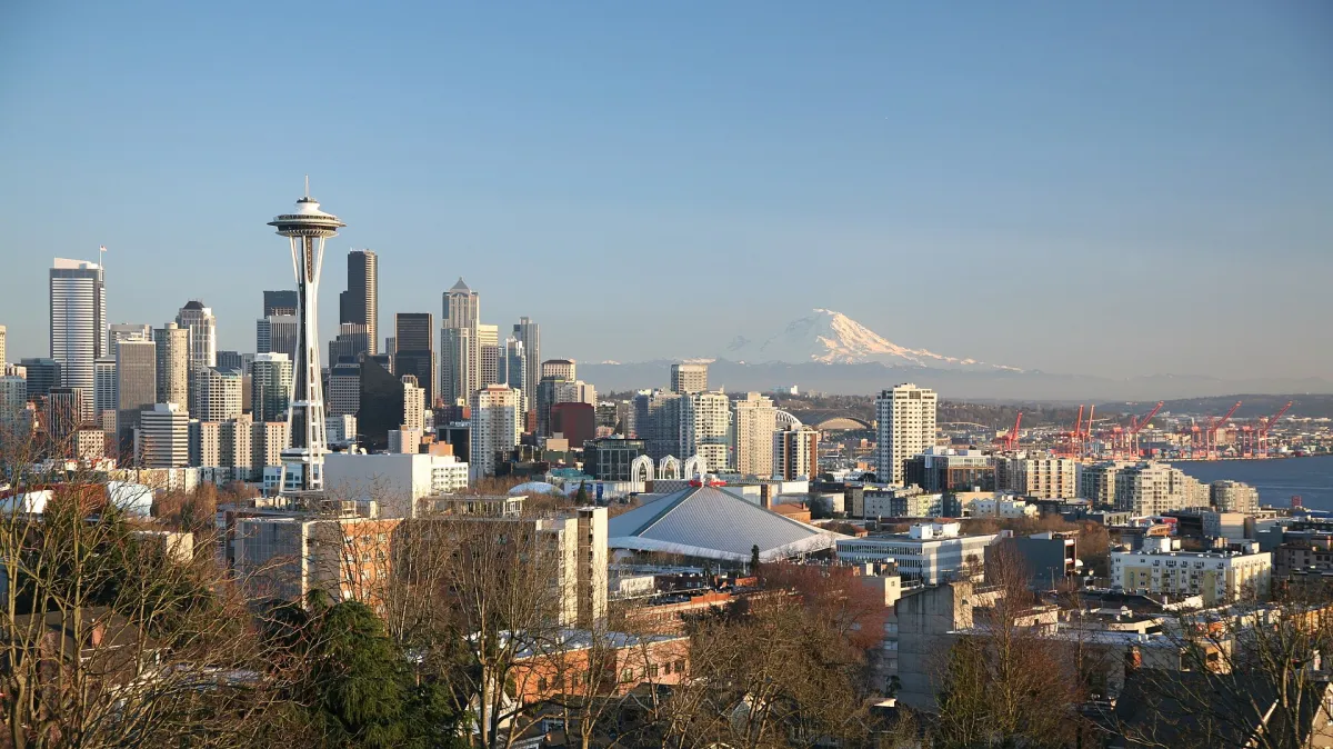
The Space Needle and downtown buildings appear together above a nearer layer of neighbourhood roofs and trees in this Seattle photograph from 17 February 2010. The source identifies Queen Anne Hill as the viewpoint. It does not establish the exact park or standing position, so Kerry Park is discussed below as a verified alternative rather than assigned to the image without evidence.
Read the Space Needle within the wider city
The Space Needle is easy to recognise, but the photograph also depends on its relationship with the denser downtown towers. Foreground buildings and bare branches introduce another layer between viewer and skyline. This gives the city depth and makes the hilltop perspective apparent. A tight crop around the landmark alone would tell a different story.
Check how much foreground you want before zooming in. A few roofs or branches can explain the viewpoint; a large intrusive shape may conceal the very skyline relationship you came to photograph. Move only within authorised public space. The fact that an older image has an unobstructed view does not establish access to a present private garden, terrace or rooftop.
The image’s 2010 date also matters. Seattle’s skyline has changed, and this frame should not be used as a complete guide to buildings visible today. Its useful contribution is the specific arrangement of Space Needle, city and foreground from Queen Anne Hill, with that historical scope made clear.
Decide how much of the Queen Anne foreground to retain
The roofs and trees in the lower part of the reference establish that the viewer is looking across a neighbourhood towards the skyline. They can make the city feel layered rather than remote. Consider what happens if they are removed: the Space Needle and downtown become a more isolated architectural group. That may be a useful alternative, but it changes the image from a hilltop city portrait into a narrower skyline study.
Look for the strongest foreground shapes and compare them with the landmark’s position. A small branch near the edge may supply texture, while a large shape crossing the Space Needle can compete with the main subject. Make the comparison from the public area available to you. An apparently clearer view over a nearby property does not establish permission to enter it, and the source’s broad Queen Anne Hill location does not identify a particular private or public platform.
In a compact finished image, the spacing between the Space Needle and the taller downtown group matters more than tiny details. Try a frame that keeps that relationship clear, then one that includes more neighbourhood context. Review the two together. If they tell the same story in almost the same way, retain the stronger one and spend the remaining time on a genuinely different observation rather than making more near-duplicates.
Use a verified public viewpoint as the alternative
Visit Seattle identifies Kerry Park as a skyline viewpoint, including the Space Needle and Elliott Bay, with Mount Rainier visible only when conditions permit. This makes it a practical place to investigate for a current outing, without claiming that every Queen Anne photograph was made there.
Choose the approach according to your mobility and transport plan. A location on a hill can involve a different walk from what a short map distance suggests. Confirm the current route and park arrangements before arrival, and remember that a popular viewpoint is also a neighbourhood public space. Keep entrances and pedestrian routes open.
The reference does not promise a mountain backdrop. If Rainier is hidden, decide whether the buildings and water make a complete composition on their own. Waiting solely for a mountain to appear can consume an outing without improving the city photograph you already have.
Let visibility decide the framing
A clear day may allow a broad city-and-bay view, while haze or low cloud can make a smaller grouping of buildings more effective. Judge the farthest layer before committing to a panorama. If the skyline merges into the background, look for nearer structures with clear separation rather than assuming that a stronger digital effect will restore detail that is not visible.
Light also changes the apparent prominence of the Space Needle. If it is much brighter than its surroundings, it can become the main subject even in a wide frame. If the landmark and downtown have similar tones, use their spacing and outlines to organise the image. Compare the result at normal viewing size, not only when zoomed in on the screen.
For a short series, make a broad skyline, a more concentrated relationship between the Space Needle and downtown, and a frame that deliberately includes the foreground neighbourhood. These are distinct observations. They are more useful than treating every slight adjustment as a separate Seattle photo spot.
Prepare a useful skyline plan for limited visibility
Use the reference to separate the scene into three possible subjects before choosing your outing. The Space Needle and dense downtown group occupy the left; the pale mountain sits behind the lower city towards the centre-right; red waterfront cranes form a smaller pattern farther right. Those subjects do not depend on one another to the same degree. On arrival, check which outlines remain legible against their backgrounds and choose the subject you can actually describe, rather than treating every missing distant feature as a failed version of this historical picture.
Frame boundaries matter when visibility removes one of those layers. A city-focused picture needs enough room around the Space Needle and the tallest neighbouring forms; a waterfront study needs to show why the cranes belong with the water rather than leaving them as indistinct marks at the edge. Keep the nearer roofs as deliberate context or exclude them cleanly. Compare the frame at its intended display size before deciding that a more distant subject adds useful detail. This is a choice about the finished picture, separate from waiting for a clearer mountain backdrop.
Keep the source date in mind when comparing buildings. February 2010 records one historical skyline and a particular foreground, not a complete guide to present construction. For your own photographs, note the place you can actually establish and any relevant date or conditions. This gives the finished image a useful context without claiming an exact camera position merely because a later viewer recognises the same landmark.
The bare branches and nearby roofs visible in the February reference are useful reminders that a foreground can change as well as the skyline. A visit in another season may produce a different balance of foliage and buildings from the same general hill. Assess what is actually visible before trying to match the older frame. A present tree or roofline can become part of your own composition rather than a defect to remove in pursuit of a historical arrangement.
Plan for a comfortable hilltop session
An exposed viewpoint can be less sheltered than the streets below. Keep your belongings secure, check the conditions and leave enough time for the return journey. If rain or poor visibility arrives, an authorised lower-level urban composition may fit the day better than continuing to wait for a distant skyline.
Use the wider USA guide for the trip’s transport and accommodation decisions. This page has a narrower purpose: understanding the Queen Anne perspective, choosing a verified alternative and avoiding unsupported claims about the original camera position. Retain the creator’s source, licence and date, and do not turn the photograph into evidence of current opening hours, equipment permissions or first-hand visit experience.
Continue planning your USA trip
Sources and further reading
FAQ
Was this definitely photographed in Kerry Park?
The source identifies Queen Anne Hill, not an exact park. Kerry Park is a separately verified suggested viewpoint, not an invented geotag for the reference.
Is Mount Rainier guaranteed in the view?
No. The tourism authority describes it as an occasional backdrop. Visibility and weather determine whether it appears.
Why is the image dated 2010?
The date keeps the skyline’s historical context clear. The composition is useful, but the photograph is not a current inventory of Seattle buildings.