USA TRAVEL GUIDE
USA Attractions: Landmark Choices, Access and Regional Context

Choose American landmarks for the places you want to understand, the effort you are comfortable making and the region your trip can realistically cover. An urban square, a bridge viewpoint and a desert arch each ask for different planning. This selection explains what makes five contrasting places useful to a visitor and which access decisions come before arrival. It is a set of regional choices, not a proposed cross-country checklist. The Things to Do guide focuses on experiences such as a performance or architecture cruise; this page helps you decide which specific places deserve time in the route. Conditions, access and permissions must be checked for your travel date.
Choose places by the visit you want
Ask what you want from the stop: a view, an understanding of local history, time in a landscape or a walk. Then compare how you reach it and what remains to do after parking or leaving public transport. A landmark photographed from a distant overlook can create a different expectation from the experience available at ground level. Read the caption and the access information together.
Do not combine these five places simply because they share a national guide. The San Francisco and Big Sur choices can fit a California journey when road conditions allow; Zion and Arches need a separate Utah plan; Jackson Square belongs to time in New Orleans. A country guide helps identify those differences. The itinerary should still leave enough time at each base to visit rather than only arrive.
Check the official source closest to the visit: the bridge authority, park service, road agency or the actual museum or site operator. General tourism information helps identify a place, but the operational question may belong to another authority. Keep a nearby alternative so a closed road, unsuitable walk or unavailable space changes the day without forcing an unsafe substitute.
Swipe horizontally if needed to compare all columns.
| Place | Visit type | Decision before arrival |
|---|---|---|
| Golden Gate Bridge | Crossing or designated viewpoint | Which side, viewpoint and return connection? |
| Jackson Square | Historic urban setting | Public-space visit or separate museum entry? |
| Zion Canyon Overlook | Moderate rocky trail | Does the terrain suit the party, and is access available? |
| Delicate Arch | Close hike or distant viewpoint | Which perspective matches the effort you can make? |
| Bixby Bridge | Part of a lawful coastal journey | Current Highway 1 access and designated stops beyond the bridge |
Golden Gate Bridge, San Francisco
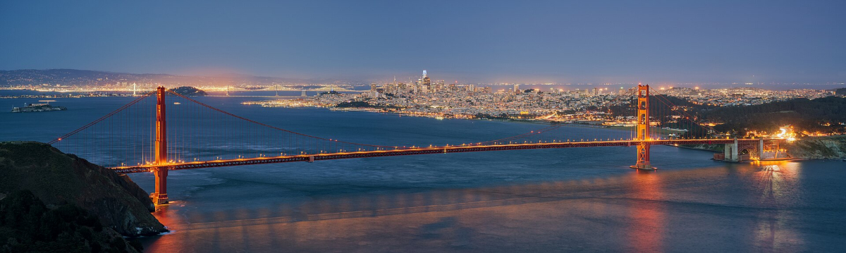
The Golden Gate Bridge is a useful choice for travellers interested in engineering, the relationship between city and bay, or the landscape around San Francisco. Seeing it from the shore or headlands is a different visit from crossing its pedestrian sidewalk. Choose the viewpoint and transport first, then decide whether a walk across part of the bridge adds something to the day.
The bridge authority's visitor rules explain pedestrian access on the east sidewalk and seasonal opening arrangements. Check current construction alerts before relying on a particular evening walk. A photograph taken from the northwestern headlands does not show the pedestrian route on the bridge itself; match the plan to the place you intend to stand.
For the elevated headland view, Hawk Hill's NPS information establishes the site's relationship to the bridge and bay. Use designated paths and the current access arrangements. Fog, wind and changing visibility are part of the coastal setting. Allow flexibility instead of treating a clear bridge view as a timed guarantee or making an unsafe roadside stop to reproduce a photograph.
Pair the visit with a manageable part of the surrounding landscape rather than adding every nearby viewpoint. If the crossing is the priority, understand how you will return. If the view is the priority, choose an accessible designated setting and give yourself time to look without assuming the most distant viewpoint is automatically the best visit.
Jackson Square, New Orleans
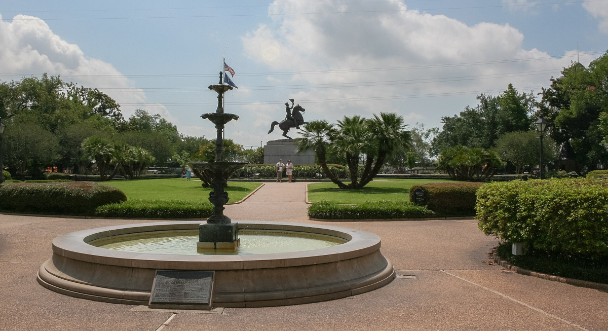
Jackson Square helps a first-time visitor read the French Quarter's historic centre. The cathedral, the Cabildo and the Presbytère form a recognisable ensemble, while the surrounding streets lead into the neighbourhood's shops, homes and cultural life. Choose this stop for architectural context and a more attentive introduction to New Orleans, rather than treating the square only as a background for an evening out.
The city's historic-attractions guidance explains the nearby buildings and their different roles. The square, an active cathedral and a museum visit are separate experiences. If you intend to enter a particular building, check its own current opening, ticket and visitor arrangements instead of assuming that everything visible from the square is included in one admission.
For broader context, the Jean Lafitte French Quarter Visitor Center offers an introduction to the lower Mississippi delta's history and traditions. Choose one or two interests to pursue, such as local architecture or cultural history, rather than filling a short visit with a list of doors. Respect worship, residents and working businesses as you move between the public spaces.
Keep the daytime visit and an evening performance as complementary plans. A landmark walk does not establish a music schedule, and a jazz ticket does not replace understanding the neighbourhood. Leave room for the weather and for a break; the most useful visit is one you can engage with at a comfortable pace.
Zion Canyon and Canyon Overlook, Utah
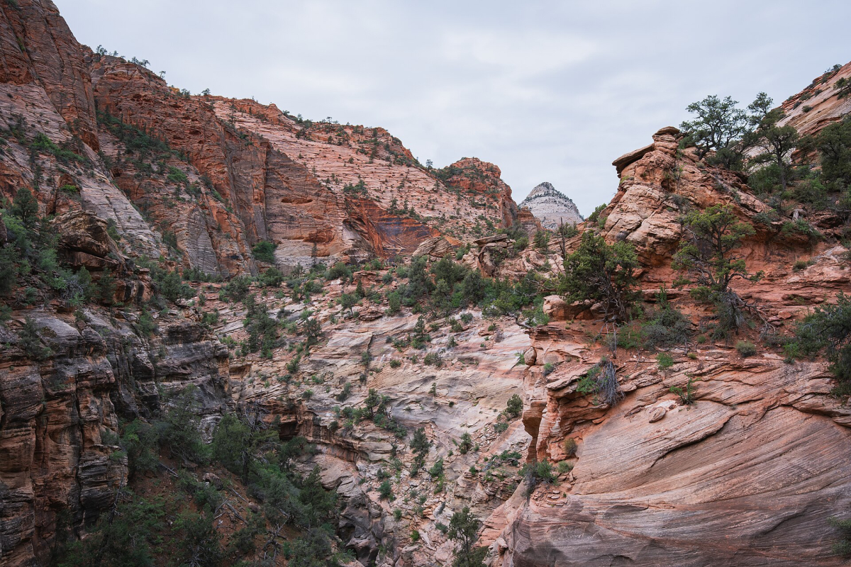
Zion offers a landscape of high sandstone walls, changes in colour and scale, and different ways to experience a canyon environment. A scenic viewpoint and a longer canyon walk should be chosen separately. The image associated with this section shows the view from Canyon Overlook, which has its own access on the park's east side rather than being a stop reached simply by boarding the main canyon shuttle.
The NPS Canyon Overlook description calls the route moderate and gives a one-mile round trip. It includes sandstone steps, rocky ground and constrained sections; a short distance does not make it an easy paved stroll. The trailhead is near the Zion–Mount Carmel Tunnel, and parking is extremely limited. Plan an alternative rather than treating a space as guaranteed.
Check the park's current road, shuttle and trail information for your dates. Entrance arrangements, a hike's suitability and any separate permit are different questions. Do not transfer a permit rule for another famous Zion hike onto Canyon Overlook, and do not assume that reaching one viewpoint gives access to every route shown in the park's photographs.
Choose Zion when the route allows enough time for the landscape and a suitable activity. Keep the visit within the ability of the group, follow barriers and stay on the designated route. If the walk or parking does not work that day, an available lower-effort visit is a better substitute than attempting an unfamiliar roadside approach.
Delicate Arch, Arches National Park
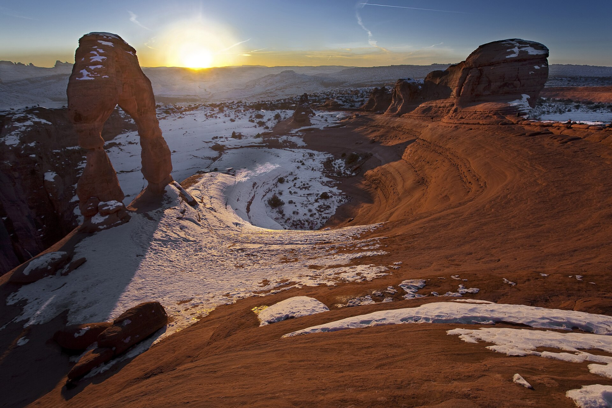
Delicate Arch is a distinctive place to consider on a Utah journey, but deciding how to see it matters as much as deciding to visit. The close view most often photographed requires a different walk from the distant viewpoints. Choose the option that matches your fitness, time and the conditions rather than assuming the arch stands beside a convenient road pullout.
The park's Delicate Arch information describes the main hike as roughly three miles round trip with about 480 feet of ascent. It also explains the separate Lower and Upper Viewpoints. The lower viewpoint provides a distant view; it does not reproduce the near-arch perspective. Check the current detailed trail and accessibility information if surface, gradient or steps are important to your party.
Heat, winter ice and crowded parking can change the practical visit. Choose footwear, water and a return plan appropriate to the actual trail. A sunset visit also means planning the walk back after the light changes. Do not add a fixed distant driving commitment immediately after a walk whose pace and parking access you cannot predict.
Stay on the established route and respect the park's restrictions. The arch is not a structure to climb, and the surrounding desert contains fragile biological soil crust. A worthwhile view does not require occupying the landscape for a photograph at other visitors' expense. If the close-up hike is unsuitable, decide honestly whether the distant viewpoint meets your aim for this trip.
Bixby Bridge and the Big Sur coast, California
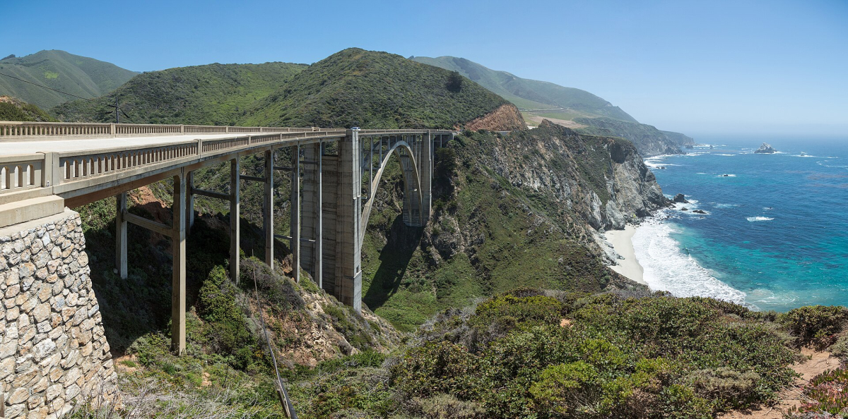
Bixby Bridge belongs in the context of a carefully planned Big Sur coastal journey. Its arch and canyon setting explain why the structure is so recognisable, but a historic or scenic photograph is not a promise of a safe place to stop today. Choose the coastal drive for the landscape as a whole, with legitimate stopping places and road conditions checked before setting out.
Visit California's current advice says not to stop or park at either end of the bridge or attempt to pull over near or along it. Beyond the bridge, use clearly designated areas. Do not make a slow traffic obstruction, a U-turn or private-property access part of a photo plan. The view shown here explains the location; it does not recommend recreating the photographer's position.
Use Caltrans road information and current alerts for Highway 1 before booking or travelling. Coastal access can change, and an older reopening announcement is not proof of an uninterrupted through-route on your date. Confirm that you can reach the intended accommodation and return by a suitable route rather than accepting a speculative minor-road diversion.
Allow enough time to enjoy available parks, towns and designated coastal viewpoints without rushing between photo stops. If road access or visibility removes the experience you wanted, shorten the coastal stage or use another regional plan. A bridge crossing should remain a normal part of a lawful journey, not an obligation to stop at a famous image location.
Continue planning your USA trip
Sources and further reading
- Golden Gate pedestrian rules
- Hawk Hill NPS
- French Quarter historic attractions
- French Quarter visitor centre
- Zion Canyon Overlook
- Delicate Arch
- Bixby official tourism advice
- Caltrans conditions
FAQ
Can these five attractions fit one short USA trip?
They are regional alternatives, not a proposed short circuit. Choose the places that fit the itinerary and allow time for the actual visit. California, Utah and New Orleans create different route decisions.
Does a short trail always mean an easy visit?
No. Steps, rock, exposure, gradient, heat and the return journey matter. Read the current detailed route description and choose an alternative when the walk does not fit the group.
Is the main Delicate Arch hike the same as the viewpoint?
No. The closer main-trail experience and the distant Lower or Upper Viewpoints are distinct options. Check the route, effort and perspective before choosing.
Can I park at Bixby Bridge for the standard photograph?
Do not plan to stop or park at the bridge ends or near or along the bridge. Follow current official advice and signs, and use only designated areas beyond it where permitted.