USA TRAVEL GUIDE
Houston Skyline Photography from the Buffalo Bayou Side
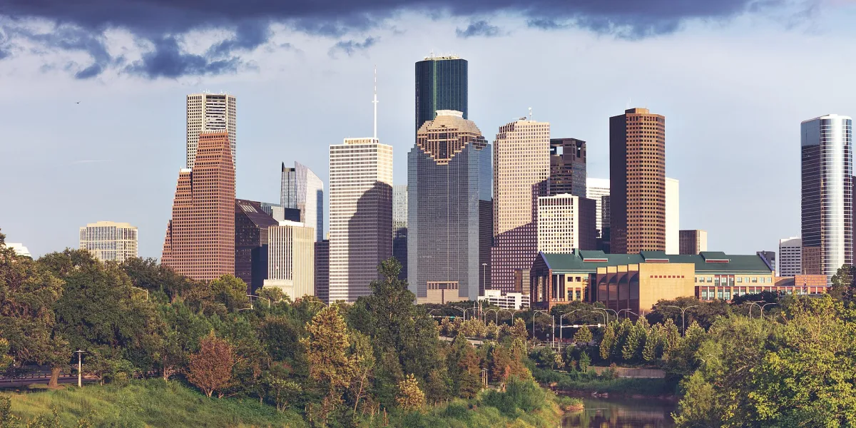
This 16 September 2018 photograph shows downtown Houston from the west, over Buffalo Bayou. Trees and lower foreground forms soften the transition to the concentrated line of towers. The exact standing position is not established here, but the west-side relationship is documented by the source. That makes the image a useful study of how Houston’s skyline can be photographed through its bayou landscape.
Read the greenery as part of the city portrait
Look at the different kinds of line before treating the vegetation as one green band. The treetops have irregular edges, while the buildings repeat grids of windows and long straight sides. A row of pale streetlights curves across the lower city. These smaller man-made forms connect the planted foreground with the towers and help the photograph read as an inhabited urban landscape rather than a remote observation of buildings.
The two outer edges offer different framing problems. A low, pale building is partly hidden by trees on the left; a rounded glass tower nearly reaches the right border. Check whether a new frame gives those edge shapes a deliberate role. A tighter crop can cut through a building even when the central skyline remains attractive. Review the entire boundary before moving on, and make any change from the open path rather than entering vegetation to improve a margin.
Separate building shapes without losing the bayou foreground
Houston’s downtown towers form a dense group in this frame, but their different heights and tones keep the outline readable. Begin with that collective shape rather than trying to isolate every building. The nearer greenery establishes distance and provides a softer lower edge. If you remove it entirely, the picture becomes a more concentrated architectural study; if you allow it to dominate, the skyline can become a small background detail. Both are possible choices, but they communicate different things.
Look for accidental overlaps near the skyline’s most distinctive edges. A branch crossing the top of a tower may appear unimportant while you are at the location, then become distracting in the finished photograph. Moving a short distance along an open path can change that overlap. Keep the movement modest and lawful: there is no need to enter planted areas or approach the bayou edge solely to clear a foreground obstruction.
Compare a broad arrangement of the downtown group with a smaller section containing a few contrasting façades. The first explains the city’s position beyond the green corridor. The second can reveal the rhythm of neighbouring buildings. A small series built around those two purposes is more informative than several nearly identical skylines. Caption the perspective as west of downtown over Buffalo Bayou unless you can document a more precise camera position for your own image.
Choose a current park approach
Buffalo Bayou Partnership describes Buffalo Bayou Park as a landscape just west of downtown, with paths and visitor facilities. Use the current park map and notices to choose an approach that suits your mobility and the time available. A viewpoint accessible from one entrance may involve more walking from another.
The reference’s west-side perspective should not be converted into an invented geotag. Bridges, lawns and paths can all create different alignments of the same towers. Choose a lawful location with a clear walking route and inspect the foreground before settling on the composition. Follow temporary closures and event instructions even when an older photograph appears to show an open area.
Work with heat, weather and changing visibility
City haze can reduce separation between buildings, while more direct light may emphasise differences in façades. Before committing to a broad skyline, check whether the towers are distinct enough at the size you intend to share. A tighter frame can sometimes communicate more clearly than a wider image in which every structure becomes small and low-contrast.
Plan your outing for the actual weather rather than the appearance of this September reference. Open stretches of park can feel hot, and wet conditions can affect paths or access after rain. Check current notices before heading towards low-lying sections. If conditions deteriorate, choose a comfortable alternative rather than waiting beside the bayou solely for a particular colour in the sky.
Distinguish personal photographs from organised shoots
A brief personal photography stop and a professional production are different activities. Buffalo Bayou Partnership’s permit guidance identifies professional or commercial photo and video work among activities requiring permits, and lists separate considerations for the Cistern. Check the applicable category before arranging models, lighting, paid sessions or a larger group.
Even when your visit is informal, keep paths and entrances open. Step aside to review images, avoid putting equipment where runners or cyclists may pass, and do not use a busy bridge as a storage area. Permission for one site or activity should not be assumed to cover another part of the park. The reference photograph is not a record of current shooting approval.
Choose a park session with a workable beginning and end
Start with the current park map and decide which entrance and authorised paths fit your available time. Choose one likely skyline view and a nearby alternative before setting out. This reduces the temptation to spend the whole outing chasing an angle that may be hidden by present vegetation, an event or a temporary closure. The source photograph gives a useful west-side relationship, but it cannot settle the details of your current route.
Make the main photograph while conditions are comfortable, then use any remaining time for a different foreground or a tighter architectural view. If the outing includes other activities, leave room for them rather than treating the park only as a platform for the skyline. The photographs can explain both the concentrated downtown buildings and the experience of approaching them through a green landscape. Those are the two elements that make this particular subject useful.
When preparing an organised shoot, resolve the relevant permit category before inviting people or bringing a larger setup. For a brief personal visit, keep the equipment easy to carry and the paths usable. At the end of the session, review your images from a stopping place rather than while walking through a busy route. A well-chosen, clearly described view is a complete result even if the weather does not produce the evening illumination you originally imagined.
The source’s west-side description is geographic context, even though the photograph concentrates on trees and towers rather than showing a broad stretch of water. Keep that distinction in the caption. An image made over or beside a bayou does not have to include the water, but it should not be described as showing a river surface that is outside the frame. This is one reason to compare source information with the actual photograph instead of letting a location label determine every visual claim.
Build a bayou-to-skyline sequence
One useful sequence could begin with the full downtown outline, then narrow to a grouping of towers, and finish with a permitted foreground element that explains the park setting. Keep each frame purposeful. The city’s relationship with the bayou is the distinguishing feature here; generic lists of Houston attractions would not help a reader understand this particular photograph.
The source date is 2018, so visible buildings, vegetation and foreground arrangements may differ today. Retain that date and the creator’s attribution rather than presenting the image as a current conditions report. For the wider journey, use the USA guide’s transport and itinerary pages; use this page for the focused decision of how to photograph downtown from its western landscape.
Continue planning your USA trip
Sources and further reading
FAQ
Is the exact camera position known?
The source states that the skyline was photographed from the west over Buffalo Bayou. This page does not assign the image to an unverified bridge or path.
Do organised photo shoots need permission?
Check Buffalo Bayou Partnership’s current permit categories. Its guidance distinguishes professional or commercial work and Cistern photography from an ordinary informal park visit.
Does the photo show present path conditions?
No. It was made in September 2018. Current park notices and the conditions on the ground should guide your route.