USA TRAVEL GUIDE
Diamond Head and Waikiki Photography: An Offshore Sunset View
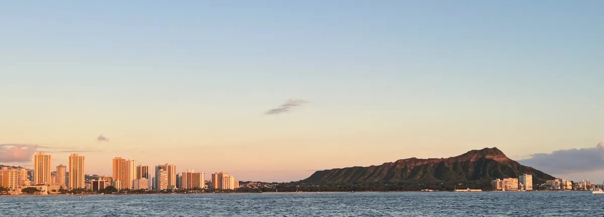
Diamond Head and Waikiki share a single long horizon in this January 2022 photograph, made near sunset from a tour boat offshore to the southwest. That source detail is essential: the picture is not the view from the summit trail and should not be presented as one. Its appeal comes from seeing the city’s shore and the crater’s profile together across open water.
Read the crater profile against the hotel skyline
The dark outline of Diamond Head gives the right side of the frame a natural anchor, while Waikiki’s buildings create a finer, more vertical rhythm to the left. The water connects these different forms. A very tight crop around the buildings would lose the relationship that makes the photograph specific to this stretch of Oahu’s coast.
Keep the horizon level and decide how much sea the frame needs. A narrow band of water can emphasise the skyline; a broader foreground can communicate distance from shore. Neither choice requires a claim about the boat’s exact route. The source records an offshore southwest viewpoint, but not a current operator, departure point or guaranteed sightseeing itinerary.
The hotel buildings occupy the left part of the reference and catch warmer light than the deeply shaded folds of the crater to the right. A narrow band of water holds the two subjects together, while a large area of pale sky keeps the long horizon calm. This balance is an option rather than a fixed recipe. A closer view of the crater could emphasise its ridges, but it would lose some of the contrast between densely built Waikiki and the larger landform. Choose which relationship you want to show before tightening the frame.
Choose offshore, shore-level or summit photography
An offshore view separates the coastline into a broad profile. A shore-level photograph instead puts beach activity, palms or a seawall closer to the viewer. A summit view looks back over the coastline from above. These perspectives answer different visual questions, so choose the one that fits your time, mobility and travel plans rather than treating them as interchangeable.
For the summit option, consult the official Diamond Head State Monument page. Hawaii State Parks identifies the trail as steep and notes reservation requirements for non-resident entry and parking. That is a separate visit from photographing the crater from Waikiki or a boat. A booking for one activity does not provide access to the other.
If your available time is short, a lawful shoreline photograph can be a complete goal in itself. Give the near foreground a role: people at a distance, a permitted public path or a stretch of water can explain where you are viewing the crater. An offshore outing requires a separate decision about the vessel, conditions and total experience. A summit visit requires its own access planning and physical effort. Combining all three perspectives into a brief period can leave each one rushed; choose the image you most want and let the other views remain optional.
Work with a moving platform near sunset
A boat’s movement changes both the horizon and the spacing between the crater and shoreline buildings. Make a few frames when the view is clear, then review them from a secure position. Keep camera straps controlled and follow crew directions. Do not lean beyond a rail or block a passage to obtain a marginally wider angle.
Near sunset, decide whether the crater should remain a strong silhouette or retain detail. Bright sky and darker land can make an automatic exposure favour one at the expense of the other. Compare the result on screen without assuming that the reference reveals a particular lens or setting. The photographer’s exact technical choices are not needed to understand the composition.
A moving boat gives you a changing composition rather than a fixed platform. As the angle changes, a small shoreline building may appear against a dark ridge in one frame and merge into the land in another. Take advantage of a clear separation when it occurs, but keep the horizon and the people around you in view. Before moving to another deck position, secure equipment and check the crew’s directions. The source photograph’s orderly horizon does not tell us that the sea was always still or establish how much freedom passengers had to move.
Let weather and access shape the alternative
A clear horizon can emphasise the long coastline, while cloud may make the light softer or hide distant detail. Sea conditions can also affect whether an offshore outing is comfortable or operates at all. Choose a boat activity for its overall suitability, not solely for a promised photograph, and check the operator’s current arrangements directly.
If a shore-based alternative fits better, make the beach and nearby foreground part of the story. That image will not reproduce the offshore perspective, but it can communicate the relationship between resort frontage and crater in another way. Remain on lawful public access routes and avoid treating hotel grounds or private terraces as unrestricted camera platforms.
The crater’s visible ridges are important when deciding how dark to let the land become. Preserving some detail shows the texture of the slope; a stronger silhouette simplifies the profile. Check the image rather than assuming the brightest sky must be made neutral. If the available light no longer supports both, choose the version that matches the purpose of the picture. From shore, a different foreground and angle can help make a useful composition even when clouds or sea conditions remove the possibility of a broad offshore view.
Keep the reference’s season and scope clear
The source date is January 2022. The image illustrates a particular evening and viewpoint, not present beach conditions, hotel facilities or a future cruise programme. It also does not show the summit trail’s surface, gradients or access arrangements. Those distinctions help readers choose an actual photographic outing instead of mistaking an attractive coastal image for practical hiking evidence.
If you want both crater profile and summit panorama, plan them as separate photographic goals. The official park information should guide the hike, while a shoreline or offshore outing supplies the profile view. A small set containing genuinely different perspectives is more useful than repeatedly cropping this single photograph and presenting each crop as a new scene.
Keep the day’s two distinct access questions separate when planning a longer photographic visit. First decide where you can legally stand or travel to make a crater-profile photograph; then decide whether a separately planned state-monument visit is wanted and suitable. A boat ticket does not answer the second question, and a summit reservation does not identify a permitted hotel terrace for a shore photograph. A sequence combining your own clearly labelled perspectives can explain the coastline more fully than several crops of the same offshore reference, while preserving the recorded January 2022 image as its own work.
Continue planning your USA trip
Sources and further reading
FAQ
Was this photograph taken from the Diamond Head summit?
No. The source places the photographer on a tour boat offshore to the southwest near sunset in January 2022.
Does a Diamond Head reservation cover a Waikiki boat trip?
No. State monument entry and any boat excursion are separate activities with their own arrangements. Check the official park information and the chosen operator.
Can I see the crater without hiking the summit trail?
The crater profile can be photographed from shore-level or offshore perspectives. That is different from entering the state monument or reaching the summit, and each chosen location has its own access considerations.