USA TRAVEL GUIDE
Boston Harbor Skyline Photography: Waterfront Layers and Boat Views
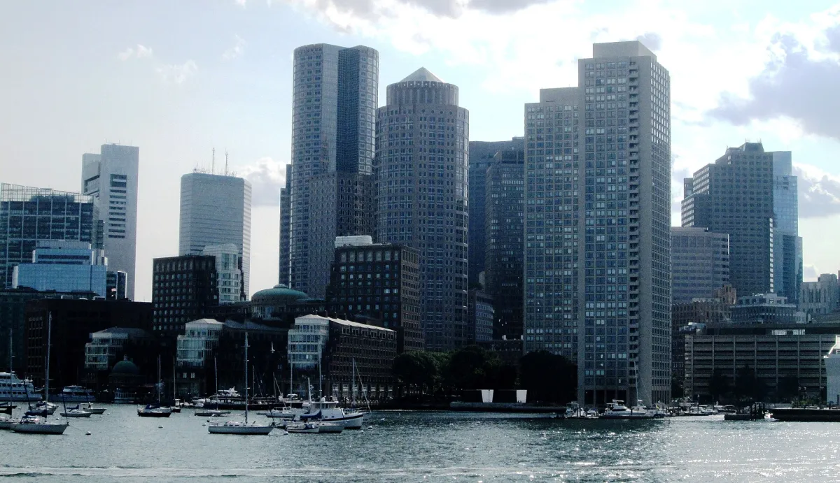
Boston’s waterfront skyline is easiest to read as a series of layers: harbour water, buildings close to the shore, and taller office blocks behind. The reference photograph was made from Boston Harbor on 16 August 2017. It is useful for studying that relationship, but it does not identify a current ferry service or guarantee the same view from a particular sailing.
Read the waterfront before the taller towers
The lower buildings at the water’s edge are part of the subject rather than obstacles to the skyline. They provide a sense of scale and connect the towers to the working harbour. The source description identifies Rowes Wharf and the Boston Harbor Hotel among the foreground buildings. Keep those waterfront layers visible if you want the image to communicate Boston Harbor rather than an interchangeable city silhouette.
The water also gives the frame breathing room. Too little can make the skyline feel pressed against the lower edge; too much can reduce the buildings to a thin distant band. Compare a balanced waterfront view with a tighter arrangement of overlapping roofs and towers. Keep the horizon level and check for an awkwardly cropped boat before deciding the composition is finished.
The large arch in the lower waterfront architecture provides a visual anchor beneath the taller, more repetitive building faces. The marina masts form a finer pattern in front of it. Keep an eye on those overlaps when making a new picture: a mast placed directly against an important edge can make the shape harder to read, while the same mast separated against water gives a useful sense of harbour scale. A different position may improve the relationship without needing to include more buildings. Use the actual outlines you can see before trying to identify every tower by name.
Decide between a shore walk and a boat
A boat can separate waterfront buildings that overlap from land and can reveal the city as a continuous edge. The trade-off is movement: your viewpoint changes as the vessel travels, and you may have only a brief clean angle between other passengers and railings. Keep equipment secure, follow crew instructions and avoid obstructing a boarding area for a photograph.
For an easier pace, use a public waterfront walk to test compositions without a moving platform. Meet Boston describes the HarborWalk as a connection between waterfront neighbourhoods and attractions. That makes it a practical framework for exploring on foot. It does not mean that every pier, marina gate or waterside terrace is publicly accessible. Follow the actual signs at each entrance.
A shore walk is especially useful when you want time to notice entrances, steps, mooring equipment and the meeting between water and built frontage. A boat instead emphasises the continuous waterfront edge. Choose one purpose for the outing. If you already have a necessary harbour journey, prepare for a possible open view without changing seats in a way that interferes with other passengers. If photography is the main reason for a paid outing, read its route and viewing arrangements before buying, while recognising that crowding, wind and the vessel’s position can change what is photographable.
Work with light, reflections and harbour weather
Direct light can make building faces easier to distinguish, while a darker skyline against a brighter sky emphasises shape. Neither is automatically better. Look at where the brightest reflection falls on the water and decide whether it leads towards the buildings or competes with them. A short change of position may remove a strong reflection without losing the overall view.
Harbour wind and haze can change an apparently straightforward session. A hazy day may suit a close waterfront detail better than a distant panorama. In cooler weather, protect your hands and keep enough time to return from an exposed promenade. Use the weather and visibility you actually have; the clear separation of buildings in the 2017 reference is not a forecast.
The reference has bright sky and areas of dark building frontage, with sparkle on the water towards the lower right. That combination can make a camera brighten the buildings at the expense of the sky, or preserve the sky while leaving the shore difficult to read. Review both parts, then decide which contains the subject. A darker architectural silhouette is a valid result when shape is the aim. If you want to study waterfront detail, a position or period with a less extreme brightness difference may serve you better than repeatedly adjusting a frame that cannot show everything equally.
Build a varied waterfront sequence
Begin with one broad image that establishes harbour, shore and skyline. Then look for a smaller composition based on a waterfront arch, a roofline or the contrast between an older shore building and a taller structure behind it. A boat can add scale, but wait until it occupies a deliberate position rather than cutting across the most important architectural detail.
The official tourism board also identifies harbour-side parks and wharves as viewing locations. Choose a manageable section rather than trying to photograph every waterfront neighbourhood in one outing. A return walk along the same stretch may reveal a better arrangement as light changes. Do not promise yourself an exact repeat of the reference: a slightly different camera position can substantially alter how the buildings overlap.
Give boats deliberate space in the composition. In this photograph, their smaller white hulls and masts help break up the broad, darker waterfront band. If you are making a new view from a moving vessel, wait for a clean gap rather than cropping through a nearby passenger or railing. From land, a small shift can change whether a moored boat overlaps an entrance or stands against open water. Do not assume every attractive boat is a visitor service or name an operator from an indistinct hull; it can simply function as a scale reference within the picture.
Keep the photograph’s date and viewpoint honest
This is a 2017 harbour photograph, not a live diagram of the present skyline. New construction and waterfront works may change what is visible. Its value is the specific study of layered waterfront architecture. Retaining that clear photographic purpose gives the page useful content beyond a generic list of Boston attractions.
For a current journey, check the operator’s own timetable and conditions before booking a boat. A sightseeing cruise, water taxi and public ferry can have different routes and boarding arrangements. Choose transport to suit your travel needs first, then treat any unobstructed skyline view as a photographic opportunity rather than a guaranteed feature of the service.
For a limited photography period, select one publicly signed waterfront segment, make an establishing view and then concentrate on a single relationship such as arch, masts and taller buildings. A longer outing can follow the publicly accessible route and compare how those layers separate from a new angle. Keep the return route and any boarding commitment in view when choosing how far to walk. The useful outcome is a set with an intelligible change of perspective, not an attempt to recreate an unspecified boat position or to cross a closed marina gate for a slightly clearer line.
Continue planning your USA trip
Sources and further reading
FAQ
Was this photograph taken from a named ferry?
The source identifies the view as Boston Harbor but does not establish a ferry or sailing. No specific current transport service is claimed.
Can I get useful harbour photographs without a cruise?
Yes. The waterfront and public HarborWalk provide land-based compositions. They will have a different perspective from the offshore reference, which can be an advantage rather than a problem.
Why keep a photograph from 2017?
Its waterfront layers remain useful for understanding composition and place. The date is disclosed so that changing buildings or access arrangements are not presented as current evidence.