
INDONESIA · BALI TRAVEL GUIDE
Bali Map & Regions: Coasts, Inland Bases & Island Connections
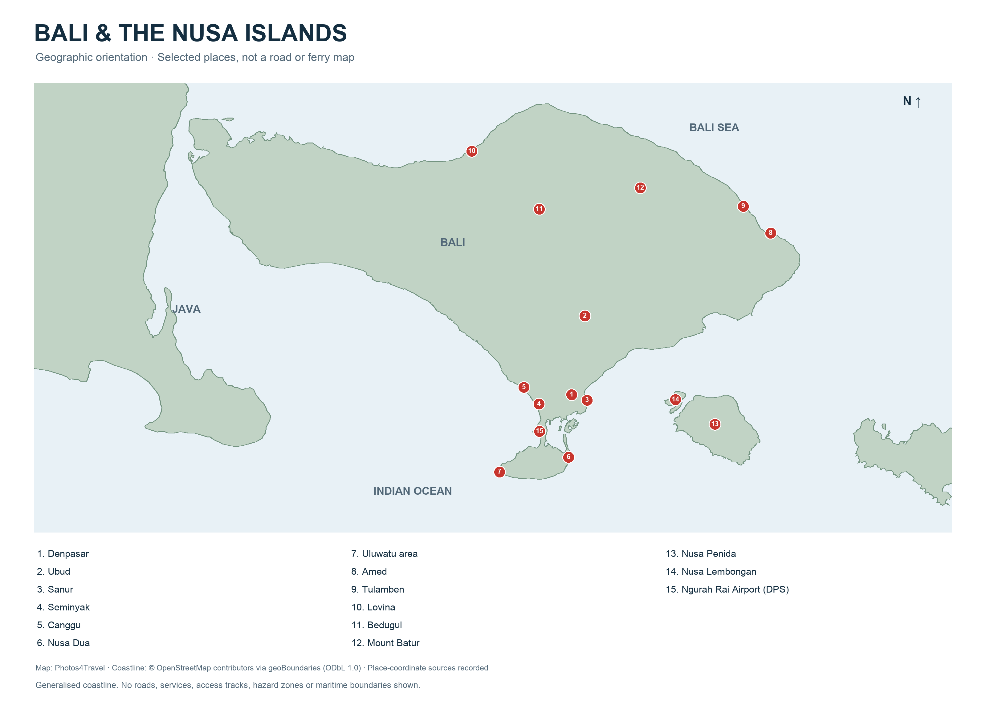
Open the high-resolution Bali map
The map opens in a new tab. Select the image again for natural-size detail, or use your browser’s zoom controls.
Bali’s shape is easy to underestimate when most of the photographs you see come from a few places. The airport and much of the visitor accommodation are in the south, Ubud is inland, and quieter east and northwest bases require a real journey. Use this geographic map to understand the relationship between places before fitting them into a route.
The map shows a generalised coastline and selected places. It is an orientation aid: it does not show road conditions, access tracks, ferry departures or hazard boundaries. The Nusa Islands are separated from Bali by sea. Crossing that gap is a transport decision, rather than the equivalent of driving to another neighbourhood.
Read Bali as a set of travel corridors
Start in the south. Ngurah Rai International Airport serves the Denpasar region but is near Tuban, beside the narrow connection to the Bukit Peninsula. Kuta, Legian and Seminyak extend along the southwest coast; Canggu is farther along that coast. Sanur is on the southeast side. Nusa Dua and the Uluwatu area are on different sides of the Bukit Peninsula.
Those relationships explain why a hotel labelled “south Bali” may not suit every outing. A coastal road journey can be slow; a trip across the peninsula can also involve a very different final approach. The map cannot tell you which hotel gate, parking area or set of beach steps you will use. Check the last part of the journey separately.
Inland Bali: Ubud, rice landscapes and highlands
Ubud is a useful inland reference point, although accommodation advertised under the name can spread well beyond the town centre. Decide whether you want to walk to restaurants and cultural venues or stay in a quieter valley setting with planned transport. The central highlands stretch beyond the most frequently photographed rice terraces.
Bedugul and Lake Beratan are in the central highlands; Kintamani and the Batur caldera lie farther east. They do not form a simple short extension of the same local walk. Check weather and current access, and group nearby visits into one corridor. Trying to cover every highland landmark on a beach-based day can leave little time outside the vehicle.
East, north and northwest Bali
Sidemen offers an inland eastern base, while Amed is a coast of several villages rather than one compact resort centre. Tulamben is a separate diving destination along the northeast coast. A traveller staying east can spend more time locally instead of repeatedly driving there from the south. Match the base to the activity and the location of your operator.
Lovina and Singaraja orient you on the north coast. Pemuteran and access to the Menjangan area are farther west. These places suit a deliberate north or northwest stay, especially when the purpose is coastal time, diving or a national-park visit. A cross-island road day should be counted as part of the holiday, with daylight and breaks built in.
The Nusa Islands: a separate connection
Nusa Penida is the larger island southeast of Bali. Nusa Lembongan and Nusa Ceningan are smaller neighbours. Their close appearance on a map should not obscure separate ports, boats, roads and local transfers. Check which island and which arrival point your ticket actually serves. A booking named after a destination area may still require another road journey after landing.
For a one-day visit, choose a focused route and leave room for sea conditions and boarding procedures. For an overnight stay, check where luggage will go and how the return crossing fits your next flight. See Ferries & Island Transfers for the separate questions of operator, harbour and connections.
Choose a corridor before counting attractions
On smaller screens, swipe or scroll horizontally to read the full table.
| Area | Useful planning focus | Journey to consider |
|---|---|---|
| Southwest coast | Beach towns, restaurants and evening venues | Traffic between coastal communities; exact hotel address |
| Sanur and southeast | Waterfront stay and access to selected boat departures | The operator’s exact check-in terminal and port |
| Bukit Peninsula | Resort coast, cliffs and particular surf beaches | East-versus-west location; steps and final beach access |
| Ubud and inland villages | Arts, food, rice landscapes and cultural outings | Town-centre walks versus accommodation needing transport |
| East Bali | Sidemen, water palaces and Amed/Tulamben coastal stays | Inland-to-coast connections and transfer back south |
| Northwest Bali | Pemuteran, Menjangan and park-oriented time | A substantial road leg and booked local access |
| Nusa Islands | Focused island trip or overnight extension | Separate sea crossing, port and onward road transfer |
Use this comparison to narrow the route, then read the dedicated page. Where to Stay answers which base suits your needs; Getting Around explains transport choices; Itineraries turns the geography into usable days. The map supports these decisions without replacing them.
Map scope and practical checks
Generalised coastlines simplify bays, small islands and harbour infrastructure. The numbered places are orientation markers; they are not hotel entrances or meeting points. Use the current operator’s pin for a transfer, the official entrance for a visitor attraction and the address supplied by your accommodation for arrival. Do not navigate a boat, hike or scooter journey from this map.
Keep an offline copy of your accommodation address and transfer details. If someone in your group needs fewer steps, a wheelchair space or assistance with luggage, ask about the complete route rather than relying on a flat-looking coastal marker. A waterfront destination can still have raised walkways, uneven approaches or boarding gaps.
For outdoor trips, current warnings and local restrictions matter more than a permanent printed symbol. Volcano access, park arrangements and sea departures can change. Recheck the relevant information before leaving, and keep a nearby alternative if your chosen corridor is affected by weather or a closure.
Frequently asked questions
Does this map show roads and drive times?
No. It provides geographic orientation with a generalised coastline and selected places. Use current routing and operator information for the complete journey.
Is Nusa Penida connected to Bali by road?
No. It is a separate island reached by sea. Your plan also needs the road journey to the departure port and local transport after arrival.
Is the airport in central Denpasar?
Ngurah Rai International Airport serves the Denpasar region but is near Tuban in south Bali. Check the airport’s actual location when choosing a first-night hotel.
Can the full-size map be used offline?
You can save the large image for orientation. It does not provide live navigation, changing access information or transport services.