
COSTA RICA TRAVEL GUIDE
Costa Rica Map & Regions: Choose Coasts, Bases and a Workable Route
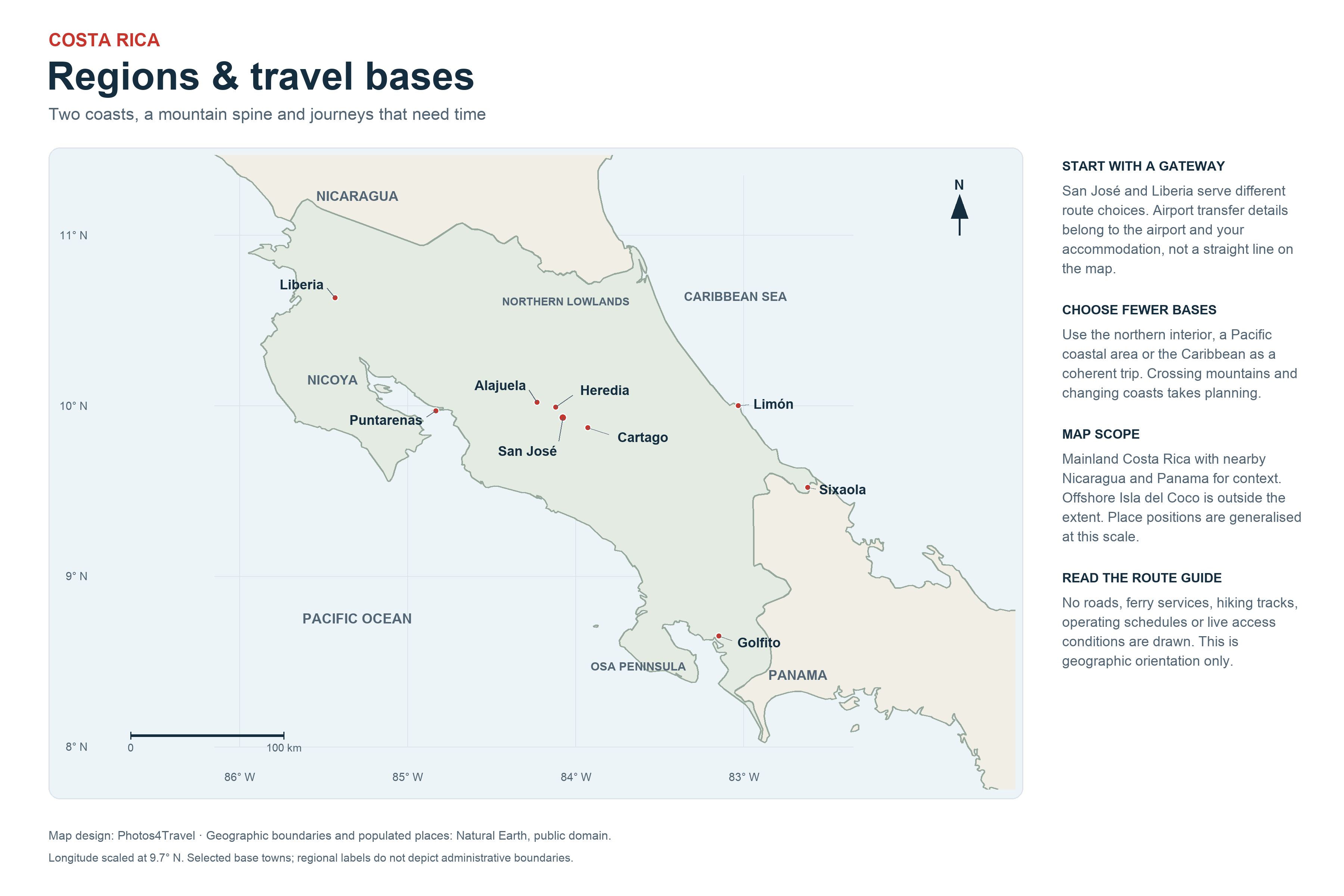
Open full-size Costa Rica map (3600 × 2400)
The map opens in a new tab. Select the image or use your browser’s zoom controls to inspect the labels.
Read the map as a route, not a checklist
Costa Rica looks compact on a world map, but a short straight line can cross mountains, a gulf or a protected landscape. Road access, river mouths, ferry departures and the final approach to an accommodation base matter more than how close two labels appear. Choose a small number of connected regions before booking hotels. Our Itineraries guide turns these choices into example routes.
The regions below are practical travel groupings, not a new set of administrative provinces or a claim that each has one weather pattern. Match each hotel and attraction to its exact location. Names such as Playa Hermosa recur in different parts of the country; always check the province, nearest town and map pin before arranging a transfer.
Central Valley: arrival logistics and cultural time
San José and surrounding Central Valley communities provide city culture, museums and a starting point for several inland journeys. Juan Santamaría Airport, SJO, is in the Alajuela area rather than downtown San José. An airport-area overnight and a stay in the capital answer different needs: one makes a flight easier, the other supports an urban visit.
Choose the actual neighbourhood and next route before reserving. A hotel described as near San José may still create an awkward cross-city journey for the following morning. Do not turn a potentially variable transfer into a fixed promise. See Airports & Transfers for gateway decisions.
Northern Plains: La Fortuna, Arenal and nearby forest experiences
La Fortuna works as a base for volcanic scenery, forest activities and hot springs. The individual attractions use different entrances and approaches; staying in the wider Arenal area does not put every visit within walking distance. Compare where you want to spend your days with the transport provided by your accommodation or operator.
Nearby on a small map does not always mean a useful same-day addition. Río Celeste needs its own approach and walking plan, while Sarapiquí offers a different lowland setting. Choose a smaller set of worthwhile outings and avoid repeatedly returning across the region only because a booking page uses the broad Arenal name.
Monteverde highlands: a separate cloud-forest stay
Monteverde and Santa Elena belong to a highland stop with a cooler, wetter feel than a lowland beach base. The town, reserves and canopy attractions are not one site. Allow for local journeys as well as the approach from your previous region, and check your accommodation's specific road rather than choosing a vehicle solely from the town name.
Combining Arenal and Monteverde can provide two contrasting habitats. It still requires a transfer; the lake and mountain landscape visible between them is not a straight urban connection. Compare the actual road or combined transport arrangement, including luggage, meeting points and the final drop-off.
Guanacaste and Nicoya: choose the coastal area precisely
Liberia's LIR airport is a useful gateway to Guanacaste, but the northwestern coast and southern Nicoya Peninsula should not be treated as one interchangeable beach strip. Tamarindo, Nosara and Santa Teresa have different approaches, town layouts and relationships to the airport. Compare the beach you actually want with the final road and facilities around the hotel.
For southern Nicoya, a route may involve the Gulf of Nicoya ferry or a road journey around the gulf, depending on your origin and destination. Puntarenas–Paquera and Puntarenas–Playa Naranjo are separate ferry routes. Do not choose a sailing simply because both arrival ports are on the peninsula. Use Getting Around before settling your booking order.
Central and South Pacific: coast, forest and onward choices
The Quepos/Manuel Antonio area combines an established accommodation corridor with a particular coastal national-park visit. Farther south, Dominical and Uvita support a different pattern of beach, forest and marine outings. An address above the coast may involve steep access and a vehicle even when its photographs suggest a beach stay.
Uvita's whale-tail tombolo is a tide-dependent feature inside Marino Ballena National Park, not a permanently accessible path. Farther south again, the Osa Peninsula and Drake Bay require more deliberate access planning. These places can complement one another on a longer journey; they are not all interchangeable day trips from the same hotel.
Osa and Drake Bay: plan around the access point
A Corcovado trip begins with the sector and route you will use, not only a hotel search for the Osa Peninsula. Puerto Jiménez, the Carate side and Drake Bay support different arrangements. Confirm boat or road connections, permitted baggage, transfer times supplied by the operator and the accommodation's arrival instructions before fixing the wider itinerary.
A remote lodge can be exactly the experience you want, but its seclusion affects meals, departure flexibility and what happens when weather disrupts a connection. Keep a buffer before an international flight. The Corcovado planning section explains why the visitor sector matters.
Caribbean: Tortuguero is different from the southern coast
Tortuguero is a canal-and-forest destination with water-based access and controlled turtle-viewing arrangements. Puerto Viejo, Cahuita and the southern Caribbean beaches provide a different road-based coastal stay. They share a broad side of the country, but one should not be used as shorthand for the other.
A Pacific-to-Caribbean change can be worthwhile on a longer trip, particularly when the seasonal choice supports it. It also uses a substantial travel day. Avoid adding the second coast simply to say you visited both. Compare regional conditions in Best Time to Visit.
Check the route before reserving the bases
On smaller screens, scroll within the table to compare the route decisions.
| Route element | Check first | Why it matters |
|---|---|---|
| Arrival gateway | SJO or LIR and your first night's location | Reduces an avoidable cross-country start |
| Coast change | Actual road route and transfer arrangement | Protects sightseeing time from an overfilled itinerary |
| Peninsula or remote lodge | Ferry/boat and final approach | Departure availability can determine the day's order |
| Fixed admission | Entrance, date and permitted window | A place label alone does not secure access |
Official geography and transport references checked 2 November 2026: ICT travel resources, ARESEP ferry routes and SINAC protected-area map. Check the exact destination and travel-date conditions when booking.
Map & Regions FAQs
Is SJO airport in downtown San José?
No. Juan Santamaría Airport is in the Alajuela area. Choose an airport-area stay for flight logistics or a city stay for a San José visit, and check the actual address and transfer route.
Can I judge driving time from the straight-line distance?
No. Mountains, the Gulf of Nicoya, road approaches and traffic can make the actual journey very different. Check the usable route and current conditions with your accommodation or transport provider.
Are Tortuguero and Puerto Viejo the same Caribbean base?
No. Tortuguero is a canal-and-forest destination with water-based access, while Puerto Viejo and Cahuita belong to the southern Caribbean road corridor. Choose them for different experiences and logistics.
Do all places called Playa Hermosa refer to one beach?
No. Repeated place names make the map pin and nearby town essential. Confirm the province, hotel address and destination with the transfer provider before booking.
Should I include both Pacific and Caribbean coasts?
Include both only when the interests and time available justify the transfer. A shorter itinerary can be richer with one coast and an inland base, rather than an extra long journey.
Which ferry should I use for Nicoya?
That depends on your final destination and route. Puntarenas–Paquera and Puntarenas–Playa Naranjo serve different arrival points; compare the onward road journey and current operator arrangements.