
AUSTRALIA TRAVEL GUIDE
Australia Map & Regions: Gateways, Distances & Route Choices
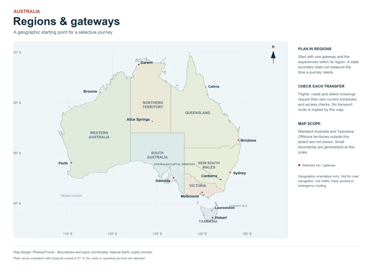
The full-size map opens separately. Use the image viewer or browser zoom to inspect its natural resolution.
Australia’s map is a planning tool, not simply a list of places to collect. The mainland’s scale, Tasmania’s separate location and the distance between major visitor regions explain why a holiday needs a geographic focus. A flight can connect distant cities, but it does not eliminate airport time or make the landscapes between them interchangeable.
Use the map to identify your arrival gateway, the region you want to explore and the next logical base. The orientation map shows real geographic relationships; it is not a road navigation product, a live transport map or a statement that a park or road is open. Check transport and access separately before committing to a route.
Read the country in regional journeys
Australia contains six states and two mainland territories commonly used for visitor orientation: New South Wales, Victoria, Queensland, South Australia, Western Australia, Tasmania, the Northern Territory and the Australian Capital Territory. Their administrative boundaries help you find the right transport and park authorities. They do not always describe the most convenient holiday route.
A Sydney–Canberra–Melbourne journey crosses administrative boundaries but can form a connected southeastern trip. A tropical Queensland holiday may stay within one state while involving long journeys between Brisbane, the Whitsundays and Cairns. Western Australia alone covers several very different climatic and travel regions. Avoid assuming that two places are near each other because they share a state name.
The practical unit for planning is a base and its realistic day-trip radius. Compare a city, its surrounding region and any overnight extension before deciding on a second gateway. Read a map together with actual road conditions, transport schedules and the number of nights available. Straight-line distance is useful for orientation but inadequate for estimating a driving day.
Swipe horizontally if needed to compare all columns.
| Region | Typical gateway to investigate | Separate planning question |
|---|---|---|
| Southeast | Sydney / Melbourne / Canberra | City stays versus coastal or inland driving |
| Tropical Queensland | Cairns for the northern reef and rainforest; Brisbane needs a separate onward journey | Actual reef marina and accommodation base |
| Top End | Darwin | Seasonal park and road access |
| Red Centre | Uluṟu-area airport / Alice Springs | Correct airport and overnight base |
| Western Australia | Perth or a northern gateway | Southwest versus Ningaloo / Kimberley distances |
| Tasmania | Hobart / Launceston | Southern focus versus a multi-night circuit |
New South Wales and the Australian Capital Territory
Sydney is the principal international gateway in New South Wales. Harbour neighbourhoods, beaches and the Blue Mountains can provide a varied introduction without changing hotels every night. The Blue Mountains lie inland from the coast; a mountain excursion is not an extension of a beach day. The Hunter Valley is another separate excursion, particularly if wine tasting requires a designated driver or an organised transfer.
Canberra sits inland in the Australian Capital Territory. Its national institutions, museums and planned urban layout give it a different role from Sydney’s harbour and coastal neighbourhoods. It can work as a cultural stop on a southeastern route, provided your transport and interests justify the detour. Treating it as an airport substitution without checking the onward journey can create unnecessary complexity.
The New South Wales north and south coasts offer many potential bases. A coastal drive becomes more useful when you choose a handful of overnight stops and allow time to leave the highway. Beaches, estuaries and headlands are separate access questions; they are not all served by frequent public transport. Use Getting Around to compare a self-drive route with city-based excursions.
Victoria and Tasmania
Melbourne is Victoria’s main gateway and a strong base for galleries, neighbourhood walks, markets and performances. The Great Ocean Road lies west of the city, while the Mornington Peninsula and Wilsons Promontory require different directions of travel. Combining all three into consecutive day trips creates considerably more driving than a compact map may suggest.
Tasmania is separated from the mainland by Bass Strait. Hobart and Launceston are distinct arrival options, and a circuit between them can reduce backtracking when flight schedules and rental terms cooperate. Freycinet is on the east coast; Cradle Mountain is in the northwest-central highlands. Their positions make a multi-night route more realistic than trying to visit both from a single Hobart base.
Tasmanian driving days need allowances for curving roads, changing conditions and stops. A short distance on a map can still occupy much of a day when combined with walking, photography and check-in. Decide whether your priority is southern Tasmania, an east-coast journey or a broader circuit. The itineraries guide explains how to keep the route proportional to your time.
Queensland and the Great Barrier Reef coast
Brisbane and the Gold Coast occupy the southeast of Queensland. Cairns and Port Douglas are much farther north. They should not be treated as neighbouring resort districts. Domestic flights can connect them, but a south-to-north coastal drive is a substantial journey requiring its own overnight structure rather than a transfer squeezed between two hotel stays.
The Whitsundays, southern reef islands and Cairns-area reef departures offer different experiences. A mainland airport is not automatically the point from which your chosen boat departs. Check the actual marina, transfer arrangements and accommodation base. An island stay may depend on an additional boat or flight with its own baggage and weather conditions.
The Daintree and Cape Tribulation lie north of Cairns. They can add rainforest to a tropical holiday, but road access, river crossings and the distance from a specific hotel require checking. Choose your base according to the experiences you have booked, not simply the broad label “Great Barrier Reef.” The Where to Stay guide compares those practical differences.
The Northern Territory and South Australia




The Northern Territory includes the tropical Top End around Darwin and the Red Centre around Alice Springs and Uluṟu–Kata Tjuṯa. These are separate climatic and geographic regions. A journey between them is not a casual overnight excursion. Verify which airport serves your intended experience, then compare a flight, an organised itinerary or a properly prepared road journey.
Darwin can be a gateway for the Top End, including Kakadu, but a park visit needs more than a city booking. Seasonal road access and the location of accommodation affect what can be reached in a day. The Red Centre needs its own night allocation and attention to heat, opening arrangements and cultural guidance. Do not assume an Alice Springs arrival places you directly at Uluṟu.
South Australia’s main gateway is Adelaide. The Barossa, Fleurieu Peninsula, Kangaroo Island and the Flinders Ranges are different regional additions. An island crossing, a wine-region day and an inland drive each have their own transport requirements. Adelaide works well as a starting point, but repeatedly returning to the city may be less practical than an overnight regional stay.
Western Australia: plan the north and south separately
Perth provides access to the city, Fremantle and nearby coast. The southwest can be developed into a road trip through towns, beaches and wine country. Margaret River belongs to that southern journey. A Perth hotel does not make every southwest attraction a comfortable day trip, especially when you want time for a walk or a meal rather than a photograph and immediate return.
Ningaloo, the Pilbara and the Kimberley occupy different parts of the state and call for their own distance calculations. An appealing coastal line on a map can disguise long remote road sections, limited services and demanding weather. Match the vehicle, fuel plan and accommodation to the actual road, and check rental restrictions before choosing a route.
For a limited holiday, Perth and the southwest can be one coherent trip, while a northern experience becomes a separate itinerary reached through the appropriate gateway. Combining them can be rewarding when the available time and transport support it. The decision should come from your route calculation, rather than the assumption that a single-state journey is necessarily compact.
Turn the map into a workable route
Place your international arrival and departure on the map first. Next, mark the nights you will actually sleep in each base. Add every flight, road transfer, ferry crossing and early departure. A route with attractive stops can become impractical once these connective pieces are visible. Remove an outlying destination before shortening every stay to compensate.
Check regional seasonality at the same time. A route spanning the southern coast, tropical north and desert may cross several different weather considerations. The Best Time to Visit guide helps interpret that combination. Keep a separate navigation product for the road, and use current official information for park closures and transport changes.
Frequently Asked Questions
Where does Canberra fit in a southeastern trip?
Canberra is inland in the Australian Capital Territory, separate from Sydney in New South Wales. Its national institutions can justify a stop on a Sydney–Canberra–Melbourne route when your interests, transport and available nights fit.
Can I drive from Melbourne to Tasmania?
There is no road bridge across Bass Strait. A mainland-to-Tasmania journey needs an air or sea crossing, with the relevant vehicle, luggage and booking arrangements checked separately.
Is Uluṟu close to Darwin?
They are in different parts of the Northern Territory. Plan them as separate regional components and check the actual transport before allocating nights.
Does this map show current road access?
No. It provides geographic orientation. Use current road authorities, park notices and transport operators for access and route decisions.