SEYCHELLES TRAVEL GUIDE
Seychelles Map & Islands: Mahé, Praslin and La Digue
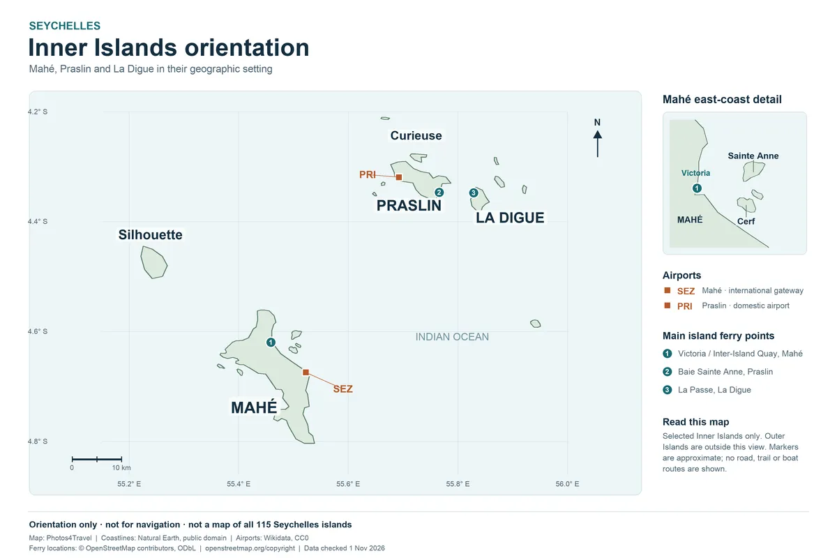
The full-size map opens in a new tab. Select the image to inspect its natural resolution, or use your browser’s zoom controls.
How to read the Seychelles islands map
Seychelles is an archipelago, so choosing an island is also choosing a transport system. Start with the relationship between Mahé, Praslin and La Digue, the three islands most visitors combine. The map is an orientation tool: it helps identify bases, airports and jetties, rather than promising a particular sailing, road condition or swimming area. Open the full-size version to read smaller labels before deciding where to sleep.
An island that looks close on a country map can require a taxi, a ferry and another transfer. Measure a proposed day by its complete door-to-door journey, including waiting and check-in, rather than drawing a straight line across the sea. This is especially important when comparing a beach hotel near an airport with a secluded property across a mountain ridge. The shortest distance is not always the simplest arrival.
| Area | Planning role | Main question before booking |
|---|---|---|
| Mahé | International gateway, capital, varied coast and mountain landscapes | Which coast fits your daily plans? |
| Praslin | Palm-forest and beach base with airport and ferry connections | Will you arrive by air or at Baie Sainte Anne? |
| La Digue | Compact island for bicycle and walking outings | Can you stay overnight instead of rushing a day trip? |
| Neighbouring inner islands | Nature or marine excursions with specific operators | Are access, landings and conservation fees confirmed? |
| Outer-island destinations | Specialist accommodation or expedition routes | Are transfers and permissions part of the actual booking? |
Mahé: separate the capital, gateway and beach coasts
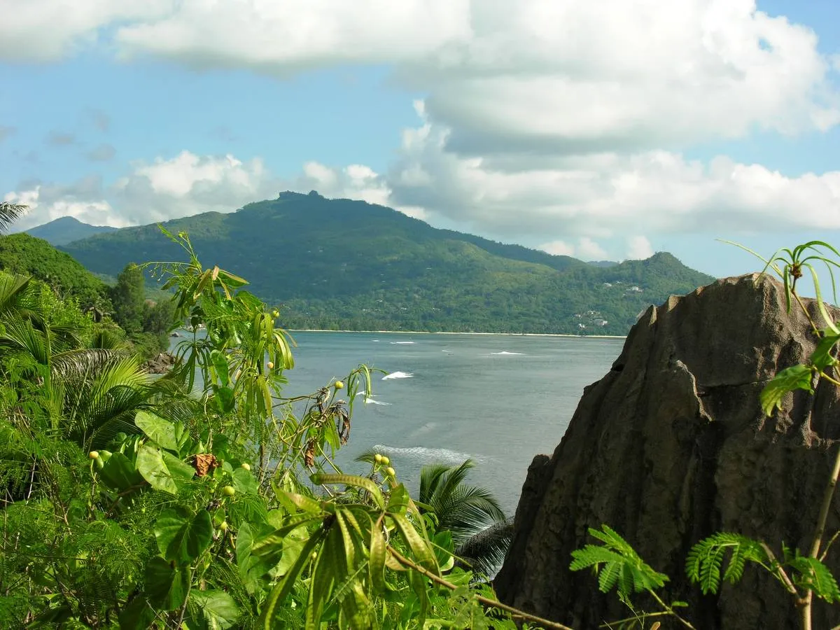
Mahé is the place to understand first. Victoria is on the northeastern side, while Seychelles International Airport is farther south along the eastern coast. Beau Vallon is on the northwestern side. These are different locations, even when a booking website uses Victoria loosely for an airport or an island address. Check the precise property pin and the name of its bay before arranging a pickup.
The island's mountain spine matters more than its outline suggests. A cross-island road can turn a nearby-looking beach into a longer outing, while an east-coast stop may fit naturally into an airport transfer. Group sights by coast or a realistic mountain crossing. For example, combining Victoria with the northern coast is a different day from exploring the south. Leave space for scenic stops without adding an unnecessary return through the capital.
Tourism Seychelles's official island overview identifies Mahé as the largest island and the home of Victoria. Use that overview for the broad island choice, then assess individual bays through the Where to Stay guide. A map can locate a beach; it cannot establish whether the water there is suitable for your family on a particular day.
Praslin: two gateways and several useful bases
Praslin has both an airport and a ferry arrival point. The airport serves the Grand Anse side; the passenger ferry gateway is Baie Sainte Anne. Do not confuse the two when comparing transfer quotes. A hotel may be conveniently placed for an early flight but less convenient for a La Digue excursion. Choose your arrival method before calculating what the first and last accommodation transfers will involve.
Côte d'Or, also called Anse Volbert, is a useful name to recognise in hotel and restaurant descriptions. Grand Anse and Baie Sainte Anne are other distinct orientation points, while Vallée de Mai sits inland. Anse Lazio is a specific beach destination, not the name of the island's main village. A sensible Praslin plan combines nearby stops and leaves enough time for the final approach and return from the beach.
The airport authority's Praslin page confirms that Iles des Palmes is a domestic airport. An international arrival in Seychelles does not mean landing directly at your Praslin hotel. Follow the airport and transfer guide for the arrival decision, and the transport guide for movements once you are based on the island.
La Digue: know the jetty side and the exposed coast
La Passe, on the western side of La Digue, is the ferry arrival area and a practical point from which to understand the island. Anse Réunion extends the accommodation choice southward. L'Union Estate and the route to Anse Source d'Argent belong to the southwestern part of a typical visitor map. A day-tripper arriving at La Passe should plan the ride, meal and return check-in rather than treating the whole island as one beach stop.
The southeastern beaches require a different outing from the west-coast village circuit. A bicycle route can include hills, and reaching one beach does not establish safe access or swimming conditions at the next. Choose footwear for any walking section and keep the return ride within your own ability. If cycling is unsuitable, arrange an appropriate transfer in advance instead of assuming a vehicle will be waiting at every trailhead.
Tourism Seychelles describes La Digue as an island without an airport. In practice, your route normally involves a ferry or another specifically arranged boat connection. There are service vehicles on the island, so the relaxed bicycle atmosphere should not be interpreted as a guarantee of completely traffic-free roads. Look behind before turning, use lights after dark and avoid a late return timed against the last available sailing.
Nearby islands: access is part of the destination
Names such as Curieuse, Cousin, Aride and Sainte Anne may appear together on an excursion map, but they are not interchangeable beach stops. Some outings centre on protected habitats or a guided landing; others involve marine activities. Compare the actual itinerary, permitted landing, operator and conservation arrangements. Seeing an island on a map gives no entitlement to land there independently or enter a protected area without following its conditions.
An excursion sold from Praslin should be assessed from your Praslin base, and one sold from Mahé from your actual hotel pickup area. A boat journey beginning near a jetty still needs a road transfer if you are staying on the opposite coast. If wildlife is your main purpose, prioritise the relevant habitat and authorised access over a long list of island names. Read the Things to Do guide for activity choices.
Outer islands need a separate planning scale
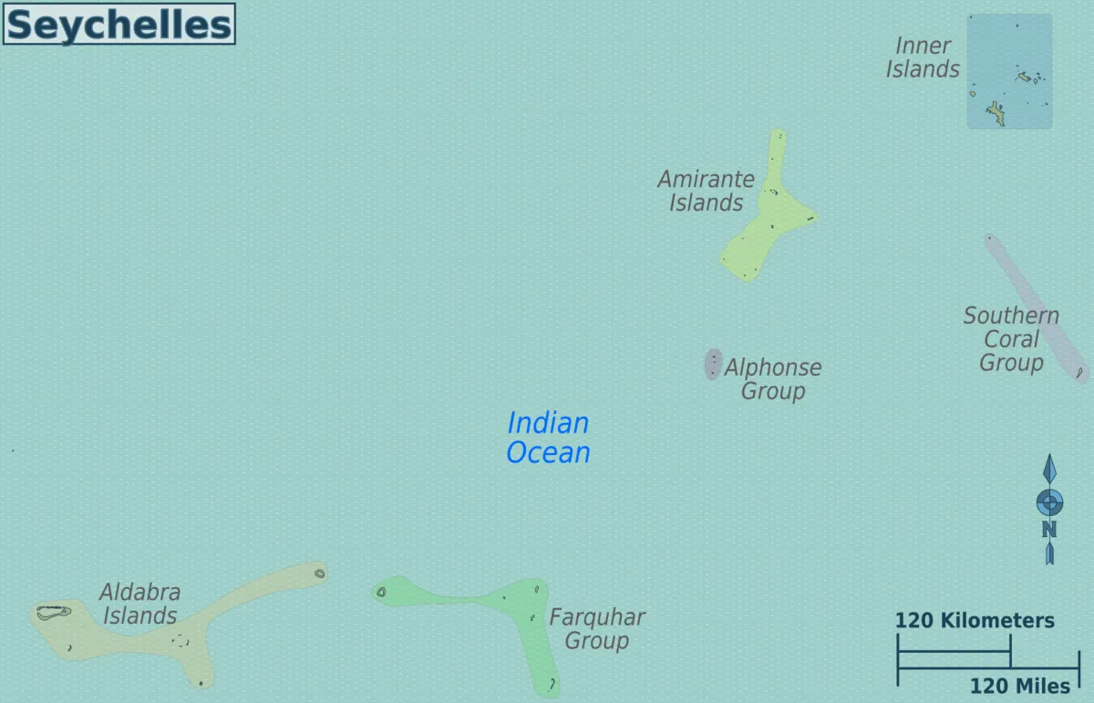
The familiar Mahé–Praslin–La Digue circuit is not a complete geographic picture of Seychelles. Outer-island trips require their own specialist arrangements; they should not be represented as easy additions to an inner-island beach afternoon. Before reserving accommodation or an expedition, establish the actual transfer method, operating days, baggage conditions and what happens if the weather changes. A resort package may organise these elements, but the inclusions must be stated in your offer.
Aldabra is particularly unsuitable for casual itinerary shorthand. Its conservation importance does not make it a routine excursion from the main islands. If it is the purpose of your trip, begin with the responsible conservation authority and a properly authorised itinerary. For an ordinary first holiday, a well-paced inner-island route usually provides a clearer plan than trying to connect every remote name printed on a country map.
Turn the map into a workable route
For a short stay, choose one main island and make outings from there. With more nights, add a second base only when it changes the experience enough to justify packing and transfers. Praslin and La Digue can complement one another, while Mahé supplies the international gateway and a different range of coast and mountain options. Use our itineraries to judge the sequence, rather than dividing nights equally by habit.
Keep an offline copy of your property location and the correct jetty or airport name. Download it before leaving reliable connectivity, and share the exact pin with your driver or host. A remote-looking shortcut on a phone map may be a private drive, an unsuitable track or a steep approach with luggage. Confirm the last part of the route with the accommodation, particularly for an arrival after dark.
Seychelles Map & Islands FAQs
Which Seychelles islands should I locate first?
Start with Mahé, Praslin and La Digue, then mark the international airport, your arrival jetty and each accommodation base. Add smaller islands only when an actual excursion or stay makes them relevant.
Is Victoria the same place as Seychelles airport?
No. Victoria is the capital on Mahé, while the international airport is a separate location farther south on the east coast. Use the actual terminal or hotel pin for transfers.
Does La Digue have an airport?
No. Plan its ferry or specifically arranged boat connection, and allow time to reach the jetty from your accommodation.
Can I use this map for roads, ferry routes or swimming decisions?
Use it for island orientation and approximate airport and jetty locations. Open the full-size map to read its labels. It does not show road, trail or boat routes, and it cannot establish current swimming conditions.
Should every island on the map be a day trip?
No. Outer islands and protected landings can require specialist transport and permissions. Select a few reachable places that match your available nights and purpose.