
Read the map as a route, not a checklist
Open the high-resolution Vietnam map
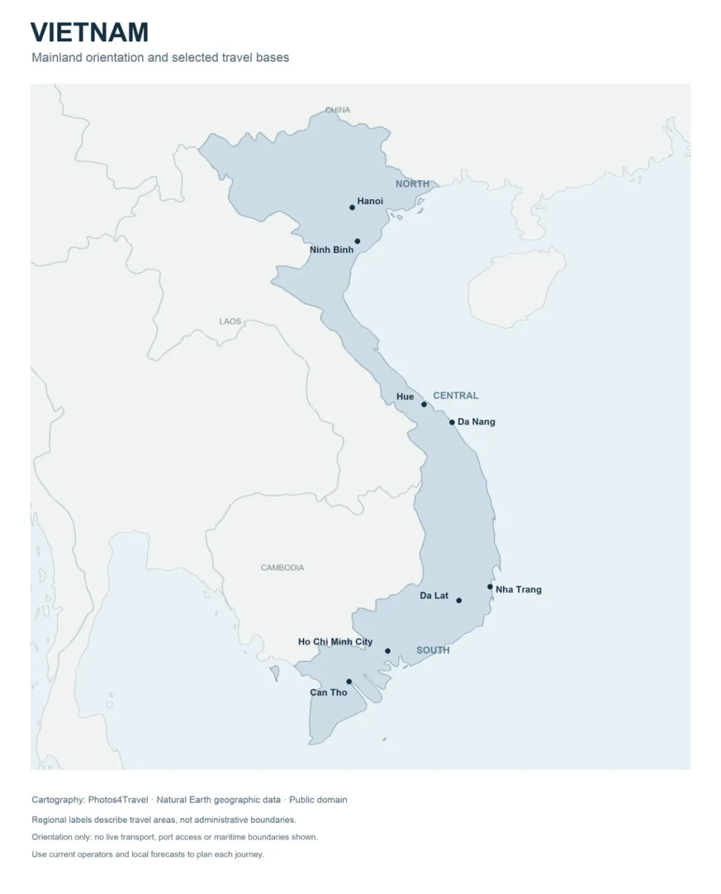
Vietnam's shape makes direction important. A route can look simple on a small map while involving a flight, a road transfer and a change of accommodation. Begin with the gateways you can realistically use, then place the bases that serve your interests between them. This map shows mainland orientation and selected city points from Natural Earth geographic data. It does not show current services, administrative boundaries, open borders or permissions to travel.
The broad north, central and south labels describe travel areas. They are useful for choosing a route, but they do not replace the current address of a hotel, airport, pier or attraction. Local administrative names can change while established tourist names remain familiar. Use an exact current address for a booking and a clear map pin for meeting a driver.
Northern Vietnam: separate the city, lowlands and mountains
Hanoi is the main city base for many northern trips. From there, decide whether the next chapter is inland limestone country, a bay trip or the northern mountains. Each involves a different approach and pace. Do not draw them as a single loop without checking how the transfers actually work. A tour pickup in Hanoi is not proof that all its destinations are close to the city.
Ninh Binh is useful as a regional name for the inland karst landscape, but the station, town centre and countryside accommodation are different points. Ask whether a transfer ends at the property or at a common drop-off. A rural stay can be ideal if the last approach and evening meals are arranged; a town base may be easier for onward travel. The official boat-tour guide helps distinguish Trang An and Tam Coc.
Ha Long Bay and the Cat Ba area add marine geography and a pier-based schedule. Confirm the embarkation port instead of searching for a generic “Ha Long” meeting point. A boat may visit a particular part of the wider landscape rather than every named bay shown in promotional material. Compare the map in the actual operator itinerary with the time you will spend aboard.
For Sa Pa or Ha Giang, allow a separate mountain chapter. The route may involve substantial road time after reaching a railway station or regional town. Sa Pa should not be treated as the same point as Lao Cai; Ha Giang is not a short stop between two nearby city hotels. Ask the operator for the day's actual start, finish and driving or walking hours.
Central Vietnam: three different base decisions
Hue, Da Nang and Hoi An are often combined, but their roles differ. Hue suits a heritage stay. Da Nang is a city and transport gateway. Hoi An is a smaller historic destination with another choice between town and beach surroundings. Look at your activities before choosing one base for the whole corridor; repeated day trips can erase the apparent saving from staying put.
The map labels Hue and Da Nang as selected city points. It is deliberately not a detailed attraction map. Use a current local map for the final approach to Hoi An, the Imperial City, a beach property or a railway station. A point labelled with a city name cannot identify the correct hotel entrance or parking area.
For the heritage context, the Hue World Heritage record and Hoi An record explain why the two places deserve different kinds of visits. Route planning should give each enough usable time instead of treating both as interchangeable old-town stops.
Phong Nha and the central inland detour
A cave-focused stay around Phong Nha belongs to its own route decision. Identify the correct arrival point and road transfer to the accommodation. Then check the excursion's meeting location, physical demands and operating conditions. A map pin inside a national park does not establish public access to a cave or permission to explore independently.
Choose the cave or outdoor activity first, then decide how many nights make it workable. An early departure or a full-day excursion may justify arriving the previous afternoon. If a long onward service leaves the same evening, consider how you will manage wet clothing, luggage, a shower and a delayed return. These small details matter more than the apparent straight-line distance.
South-central coast and the highlands
Nha Trang, Da Lat and the Phan Thiet–Mui Ne area serve different kinds of holidays. A coast-to-highland journey can change both the landscape and the driving conditions. Do not combine several of these bases simply because they sit between central Vietnam and Ho Chi Minh City on a national map. Price and time the actual connections.
Nha Trang is a city-coast choice. Da Lat is an inland highland base. Mui Ne is associated with the coastal resort corridor around Phan Thiet, east of Ho Chi Minh City rather than south of it. Use current road or rail arrangements and the exact property address when deciding how to reach a beach stay. A station or airport marketed with a destination name may still leave a significant final transfer.
Southern Vietnam: Ho Chi Minh City and the delta
Ho Chi Minh City is the practical starting point for many southern routes. Decide whether you want city days, one delta base or an island extension. Avoid treating the entire delta as a single nearby excursion. The town you choose determines the road journey, boat arrangements, meals and reason to stay overnight.
Can Tho is shown on the map as one selected delta base. It is useful for an early river outing and a stay around the urban riverfront or nearby countryside. Chau Doc, Ben Tre and other delta destinations have their own positions and access needs even when they do not appear on this simplified map. Read a specific itinerary before assuming an excursion reaches the river scene you want.
The official Can Tho guide introduces that base. For an overnight stay, ask whether the property is reachable by road, boat or both, and arrange the final part in advance. A scenic riverside location may require planning that a city hotel does not.
Islands need their own transport plan
Phu Quoc and Con Dao are not shown in detail on this mainland map. Their omission is not a recommendation to exclude them. It means an island decision should use an appropriate local map and the actual flight or ferry service. Compare the embarkation point, weather dependency, arrival time and transfer to the property before adding nights.
A ferry pier is not interchangeable with an airport, and a ticket to an island does not establish permission for a wider international border journey. Verify the entry rules and permitted crossing for your own passport and itinerary. Choose several usable nights for an island stay when that is the purpose of the extension, and protect the return before a major international departure.
Put transfer days on the map
Mark every change of accommodation, including the apparently minor move between a city and a nearby countryside stay. Add the station or airport journey at each end, waiting time and the final approach. A short scheduled service may still occupy much of a day. Use current operator information from the national tourism transport overview as a starting point.
Then count full days in each base. If the route leaves no morning or afternoon free for the activity that motivated a stop, remove a destination or add a night. For example, the seven-, fourteen- and twenty-one-day outlines keep arrival and departure days visible instead of hiding them inside sightseeing time.
Use the high-resolution map alongside current local information
Open the full image for a closer view of city positions. A browser may first fit the image to the screen; use its image zoom controls to inspect the natural-size version. The enlarged image remains an orientation map, with no live traffic, service status or current booking information.
Save a current local map for each last-mile journey and keep the accommodation address offline. Check the regional weather guide before locking in the most exposed transfer. A good national route connects places sensibly, while a good local arrival plan gets you to the correct door.
Frequently Asked Questions
Does the map show current administrative boundaries?
No. North, central and south are broad travel labels. The map shows geographic orientation and selected city points, with no live routes or maritime boundaries.
Is a Ninh Binh station arrival the same as reaching a rural stay?
No. Confirm the final transfer from the station or common drop-off to the exact accommodation. The town and the countryside visitor areas are different points.
Can I use one hotel for Hue, Da Nang and Hoi An?
You can plan trips from one base, but compare the repeated journeys with moving accommodation once. The most practical choice depends on how many days and evenings you want in each place.
Why are islands not shown in detail?
This is a mainland orientation map. Use a suitable island map and current operator information for the actual airport, ferry pier, coast and last approach.