AFRICA · SOUTH AFRICA GUIDE
South Africa Map and Regions: Plan a Coherent Route
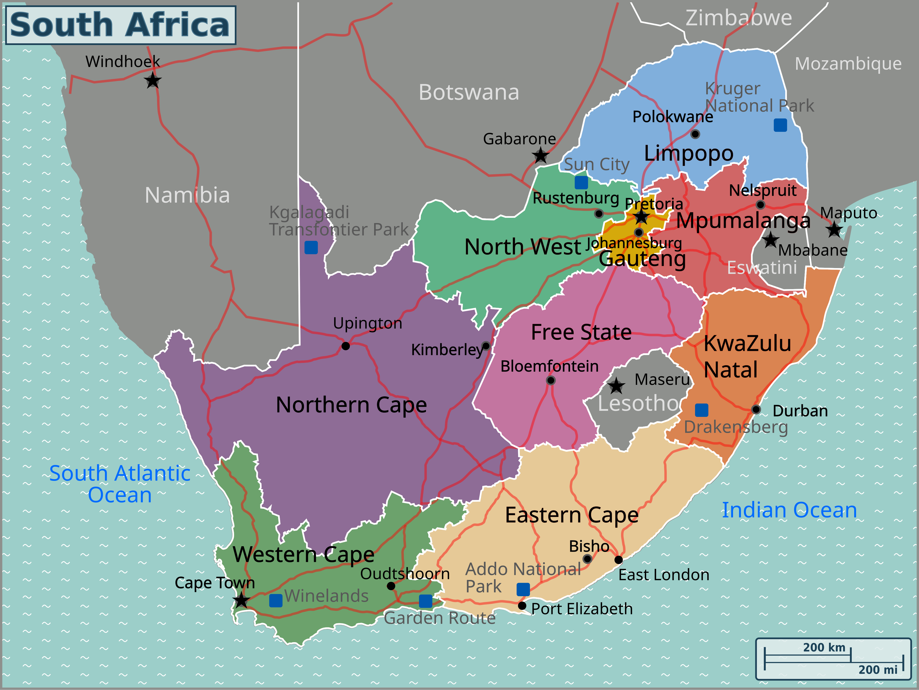
Opens in a new tab. Use the image viewer or your browser’s zoom controls to enlarge the detail.
A map of South Africa is most useful when it helps you choose a coherent route. The Western Cape, the southern coast, Gauteng and the northeastern safari areas are not interchangeable pieces of one compact destination. Begin with the regions that matter most, then connect them with appropriate flights or deliberate road stages. This page explains those geographic relationships rather than repeating a list of attractions.
Use the geographic map for orientation and the relevant operator's current map for the last approach to a park, lodge or trail. A national overview cannot show every road closure, entrance rule or property access point. The government's provincial overview is the reference for South Africa's nine administrative provinces; visitor regions often cross or sit within those boundaries.
South Africa map: provinces and principal travel regions
The map is a geographic planning reference, not a live navigation service. Read its labels alongside the regional descriptions below. Straight-line proximity does not establish a usable road, an open border crossing or the correct lodge gate. When planning a transfer, work from the actual starting address and authorised destination entrance.
Compare regions before connecting them
On a small screen, scroll the table sideways to compare all columns.
| Region | Useful travel role | Connection to consider |
|---|---|---|
| Cape Town and Winelands | A Western Cape city-and-countryside stay | Nearby regional moves rather than repeated flights |
| Overberg and Garden Route | A southern coastal journey with several possible bases | A one-way road plan with deliberate overnight stages |
| Gqeberha and Addo | Eastern Cape gateway and a southern wildlife extension | The correct park section and flight departure base |
| Gauteng | Johannesburg and Pretoria city visits or a flight gateway | Urban transfers and onward regional connections |
| Kruger and nearby private reserves | A northeastern wildlife stay | Camp or lodge access, airport and gate must match |
| KwaZulu-Natal and Drakensberg | An eastern coast-and-mountain holiday | Selected valleys and coastal bases rather than one broad pin |
Western Cape: Cape Town is a base, not the whole province
Cape Town sits in the southwest, with the Peninsula extending south of the city and the Winelands inland. Those relationships make a city stay with selected regional outings possible, but road access and traffic still matter. A viewpoint visible across the bay is not necessarily a quick stop between two other appointments. Check which side of the mountain and which part of the Peninsula your chosen place occupies.
Stellenbosch and Franschhoek can be day-outing destinations or separate overnight bases. The choice depends on your interests and transport, not only their distance from Cape Town. Staying in the countryside creates time for a slower visit; it also means arranging evening meals and tasting transport from that specific address.
Cape Agulhas lies on a different coastal journey from Cape Point. SANParks identifies Agulhas as Africa's southernmost tip. Do not place the geographic tip on the Cape Peninsula or assume that the two names describe the same outing. A map should clarify that distinction rather than reinforce a familiar misconception.
The southern coast and Garden Route: a sequence of bases
From the Cape region, a coastal road journey can pass through the Overberg towards the Garden Route and the Eastern Cape. It is tempting to turn every town into an overnight stop. A more useful plan chooses a few bases and uses nearby days for coast, estuary or forest interests, leaving the longer transfer stages clear.
The Garden Route National Park includes Wilderness, Knysna and Tsitsikamma areas. It is not a single enclosed attraction with one entrance. A reservation or trail in one section should be checked against that section's map and access information; the familiar regional name does not tell you where to park or which path is open.
Wilderness, Knysna, Plettenberg Bay and Storms River offer different practical bases. Choose according to the activities you actually intend to do, then compare the driving involved. If every outing is at the opposite end of the region, change the base or reduce the list. A nominally central point does not always produce the most comfortable holiday.
Eastern Cape: Gqeberha, Addo and a wider province
Gqeberha, formerly widely known as Port Elizabeth, is a useful gateway for a southern route. The city and airport should not be confused with the whole Eastern Cape, which includes a much broader range of towns and landscapes. An accommodation listing using the airport's regional marketing area may still require a substantial ground transfer.
Addo Elephant National Park is a distinct protected area with multiple kinds of activity and geographic context. Check the particular section, camp and entrance rather than routing to a generic park pin. An Eastern Cape private reserve is separate again: its entrance and wildlife programme come from its own operator, not from an Addo booking.
Gauteng: urban distances deserve real time
Johannesburg and Pretoria anchor the Gauteng urban region. International arrival, a city hotel, a museum and a regional departure airport may all involve separate transfers. Do not make a close-looking set of map pins into a tightly scheduled day without checking the actual route and traffic conditions.
A gateway night near an airport and a cultural stay in the city have different purposes. Choose the former for a practical connection and the latter around the visits you want to make. A well-chosen city base can reduce unnecessary transfer time, but no broad neighbourhood name removes the need to plan late-evening returns or a punctual airport pickup.
Northeast: park, reserve, gate and lodge are different locations
Kruger extends through the northeastern provinces of Limpopo and Mpumalanga. A safari described as “Kruger” can refer to a national-park stay, a neighbouring private reserve or a town outside the park. Those options may be geographically close while operating under different access arrangements. Establish exactly which one you have booked.
The official Kruger entrance information should guide national-park approaches. Nearby reserve access needs its own instructions. Sabi Sand's gate map makes the lodge-specific relationship clear. Never assume you can drive across a protected-area boundary because two lodges appear close on a national map.
The Panorama Route and escarpment area can complement a northeastern trip, but they are not a shortcut through a safari park. If you include a scenic regional day, protect enough time for its roads, stops and the next accommodation's arrival deadline. A flight into one safari gateway can be convenient for some lodges and less convenient for others.
KwaZulu-Natal and the mountains: choose a specific sector
Durban and the coast create a different eastern journey from the Cape's Atlantic setting. A coastal hotel, northern wildlife area and mountain property should not be treated as local outings from one universal base. Decide which experiences justify overnight moves and which should wait for a later visit.
In the Drakensberg, the valley and trail access point matter. A property with a mountain view can still be poorly located for a route in another sector. Check the land manager, trailhead and current conditions before booking around a saved photograph. Mountain plans also require more attention to weather and daylight than a national distance map can provide.
Borders and route checks
Lesotho and Eswatini are independent countries, not South African provinces. Namibia, Botswana, Zimbabwe and Mozambique also create international route choices. Check nationality-specific entry requirements, vehicle permission and the intended border post before including a crossing. A navigation suggestion does not establish that your documents or rental agreement permit the journey.
For every substantial transfer, confirm the starting point, correct destination entrance, road conditions, available daylight and arrival deadline. Add breaks and the time needed to return a rental car or meet a lodge transfer. Use the transport guide for operational planning and the base comparison before committing to a route.
South Africa map and regions FAQ
Is the Garden Route a province?
No. It is a visitor region along the southern coast. Administrative provinces and tourism regions serve different purposes, so use the actual town and park section when arranging accommodation or activities.
Can I treat Cape Town and Kruger as nearby road stops?
No. They are separate regional components of a holiday. Most shorter two-region plans need a flight and ground transfers; an overland journey requires substantial additional time and overnight planning.
Can I use the national map for the final lodge approach?
Use it for orientation, then follow the host's current directions and the relevant operator's access map. The national overview does not show every gate permission, road closure or property entrance.