
EGYPT · CAIRO GUIDE
Cairo Map & Neighbourhoods: Orient Your City Visits
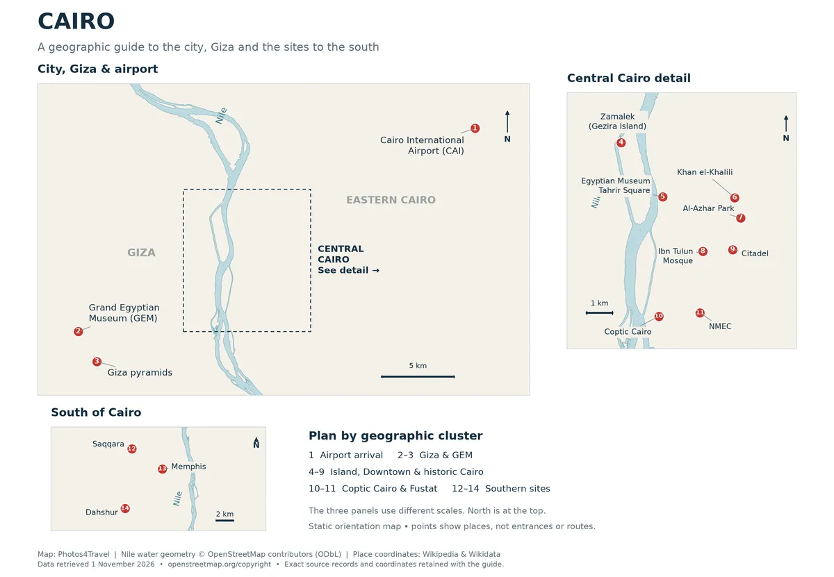
The full-size map opens in a new tab. Select the image to view its natural resolution, or use your browser’s zoom controls.
Read Cairo as several connected visit areas
Cairo makes more sense when you plan by area. The Nile provides the strongest orientation line: Downtown and much of the historic core are on the east, while the Giza pyramid plateau and GEM are to the west. Islands and bridges connect parts of the centre, but a river crossing is still a real journey. Greater Cairo’s familiar visitor names do not describe one compact walking district.
Use this geographical guide to group visits, then choose accommodation with Cairo Hotels and plan the actual route before departure. A schematic city map is an orientation aid, not a live navigation service or a guarantee of a suitable pedestrian crossing. National routes to Luxor, Aswan and the coast belong in the Egypt map and regions guide.
Swipe horizontally if needed to compare all columns.
| Area | Use it to organise | Do not assume |
|---|---|---|
| Downtown/Tahrir | Egyptian Museum, central streets and useful transport connections | Every central address has a quiet room or easy street crossing |
| Historic Cairo | Al-Muizz, Khan al-Khalili and selected religious/architectural stops | All historic monuments form one short uninterrupted walk |
| Old Cairo/Fustat | Coptic church cluster, Coptic Museum and a separate NMEC visit | NMEC shares the same entrance or grounds as the churches |
| Gezira/Zamalek | River/island outings, cultural venues and neighbourhood time | The entire island can be covered comfortably on every visit |
| Giza/GEM | West-side archaeology and museum visits | A Metro station labelled Giza is the pyramid entrance |
| Heliopolis/eastern Cairo | CAI-related arrivals and eastern city commitments | New Cairo and the historic centre are adjacent neighbourhoods |
Downtown, Garden City and the river
Tahrir is a useful reference point for Downtown and the historic Egyptian Museum. Garden City lies near the river south of this central area; neighbourhood names are more helpful when attached to an exact street than used as generic distance labels. A hotel may promote proximity to Tahrir while its approach still involves a busy road.
Plan one manageable street segment and a specific destination rather than a long unsurveyed riverside walk. Where you cross the Nile matters: bridges have different road approaches and pedestrian conditions. For a car pickup, save the actual entrance and side of the road, especially when the venue is inside a larger complex.
Historic Cairo and Old Cairo are different planning labels
Historic Cairo includes the medieval urban fabric associated with Al-Muizz and surrounding districts. The UNESCO listing describes a layered living city, rather than a single monument park. Khan al-Khalili is a useful nearby market reference, but the Citadel and other major monuments need their own transfer and visit decisions.
Old Cairo is commonly used by visitors for the Coptic church and museum area around the old fortress. NMEC lies in the wider Fustat/Ein Elsira area and requires a separate approach. Keep the names of your chosen church, museum and entrance on the route plan; “Old Cairo tour” alone does not establish which places are included.
Gezira, Zamalek and Giza
Zamalek is a Nile island district, confirmed by the Cairo Governorate overview. Plan around an actual gallery, café, station or cultural venue rather than assuming the whole island is one small attraction. The Opera area and northern neighbourhood streets represent different stops, with real distances between them.
Giza is also a broad geographical label. The pyramid plateau and GEM are west-side priorities; a Giza station or hotel name may still leave a substantial final road leg. Put these visits into deliberate blocks. Combining them in one day is a pace decision, not proof that all the collections and every pyramid interior can be completed comfortably.
Eastern bases and southern excursions
Heliopolis, New Cairo and other eastern destinations can be practical for a specific appointment or airport journey, while adding travel when most sightseeing is central or west. Check the exact address before using an “airport area” label to judge distance. CAI and SPX sit on different sides of the wider metropolitan area.
South of the main city circuit, Saqqara and Dahshur are best considered a dedicated archaeological outing with a clear return arrangement. They are not city-centre neighbourhoods. Keep the wider Egypt itinerary separate so a city orientation page does not turn a long-distance excursion into an apparently easy afternoon detour.
Turn orientation into a practical journey
Use the official Metro maps for lines and interchanges, then check the final entrance and walking approach. For a car day, group stops by side of the city and confirm the route with the provider. Allow an alternative when traffic, weather or an unexpected closure changes the sequence.
Keep a small route note for the day: start, two or three genuine priorities, a meal or rest stop and the return. This is more useful than pinning every landmark on a single map. Leave the rest as choices for another day; Cairo rewards a clear geographical plan and enough time to notice the places between the famous names.
Frequently Asked Questions
Are Historic Cairo and Old Cairo the same visit area?
The labels overlap in broad historical discussion but usually mean different visitor routes. Identify the actual monuments: Al-Muizz/Khan al-Khalili differ from the Coptic church and museum cluster.
How should I read a Giza pin on the city map?
Distinguish the Metro station, the city district, GEM and the plateau entrance. A map pin does not turn these separate places into one short walk; plan the actual onward journey.
Can I use one map for Cairo and the whole Egypt trip?
Use the city map for neighbourhoods and local grouping; use the Egypt regional map for intercity routes. They answer different distance and itinerary questions.
How many districts should I combine in one day?
Choose by your pace and transport, with a few priorities in a coherent area. Avoid assuming that several nearby-looking pins mean short, comfortable transfers.