
RUSSIA · MOSCOW GUIDE
Moscow Map & Neighbourhoods: Plan Your District Days
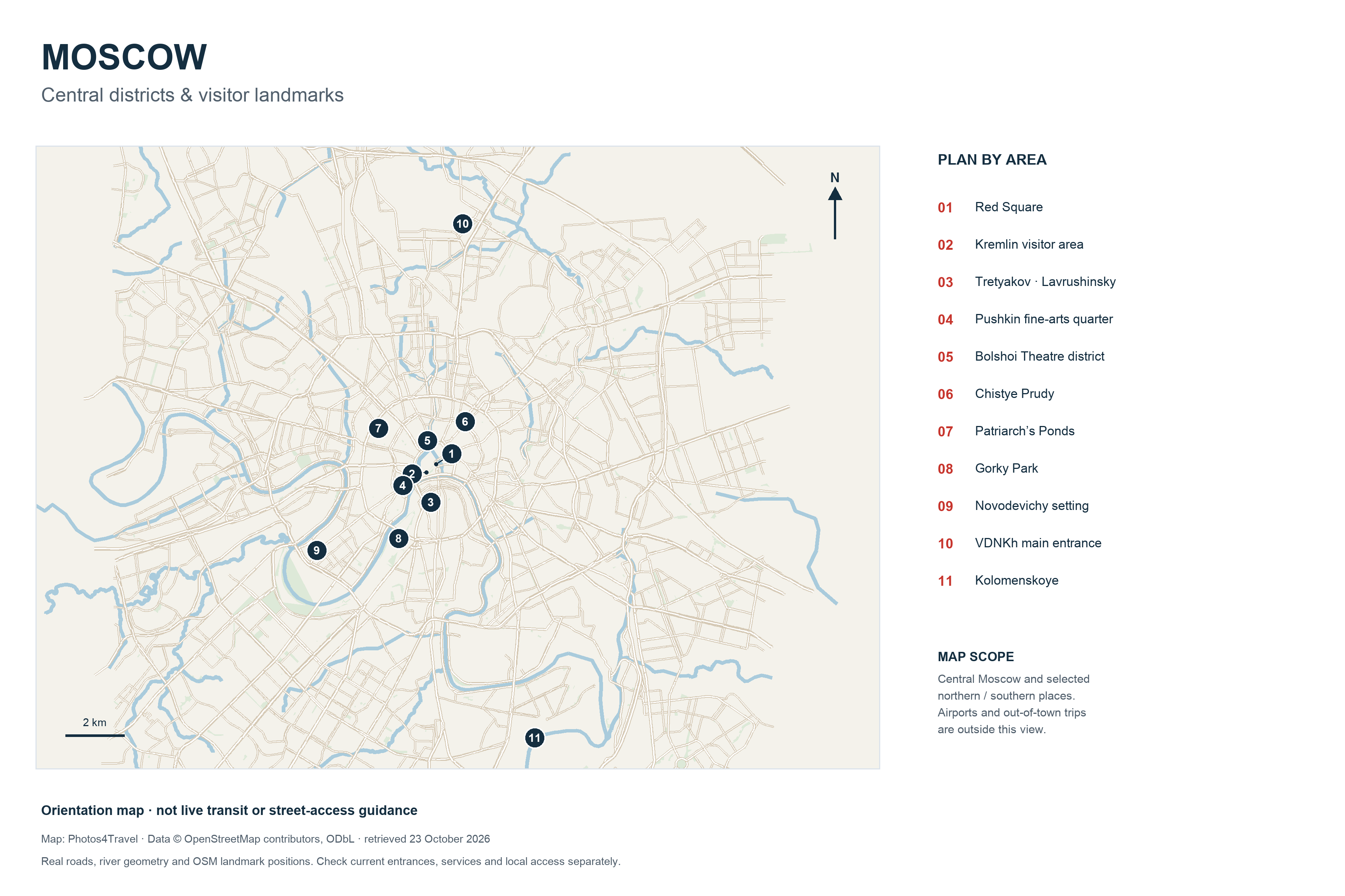
Open high-resolution Moscow map (3600 × 2400 px)
Opens the 3600 × 2400 px map in a new tab. The browser may initially fit it to the window; click the image or use its zoom controls for detail.
Use the numbered places to understand the shape of a Moscow visit. The river, roads and landmark positions come from OpenStreetMap data; this is a static orientation map, not live routing, a metro diagram or a guarantee of an open entrance. Airports and out-of-town day trips lie outside its scope.
How to read the map
On smaller screens, swipe or scroll horizontally to read the full table.
| Numbers | Area | How to use it |
|---|---|---|
| 1–2, 5 | Red Square, Kremlin and Bolshoi district | A compact central day; museum and performance entrances are separate. |
| 3–4 | Tretyakov / Lavrushinsky and the Pushkin fine-arts quarter | Different collections on different sides of the river. |
| 6–7 | Chistye Prudy and Patriarch’s Ponds | Separate neighbourhood bases and walks, not adjacent ponds. |
| 8–9 | Gorky Park and Novodevichy setting | Separate outdoor choices on the southwest side. |
| 10–11 | VDNKh and Kolomenskoye | Opposite directions; choose a substantial outing rather than joining both casually. |
A pin represents an orientation point, not a surveyed public entrance. Confirm the address and entrance for the actual ticket, especially at a museum complex with several buildings.
Choose a district for the day
Keep the historic core as one walking area, with a single principal interior. Across the river, Tretyakovskaya and the older lanes of Zamoskvorechye form a different day. VDNKh and Cosmonautics belong to a northern outing; Kolomenskoye needs its own southern route.
Use Where to Stay for accommodation trade-offs. A property farther along a major road can be a different daily base from a hotel beside the named station. Compare the final walk and usable station exit, not only a map pin.
Metro diagrams and live route planning
Use a current official Moscow Metro app for the latest network diagram, station information and changes; confirm service notices at the station. This map deliberately does not draw metro services: a historical line diagram would be misleading beside current visitor guidance.
The Getting Around guide explains Troika, transfers, station exits and accessibility. Airports & Transfers covers the airports separately; a central street map cannot establish an airport connection.
Save an offline plan
Save your hotel address in Russian, the nearest useful station and a screenshot of the final walking route. Keep a written alternative for arrival if data or SMS is interrupted. The static full-size map is useful for comparing districts, but does not replace an up-to-date route or local signs.
The map design is by Photos4Travel using © OpenStreetMap contributors, ODbL data retrieved on 23 October 2026. Labels are editorial orientation labels. Road geometry, water and landmark locations are drawn from that source rather than generated geography.
Map & Neighbourhoods FAQs
Can I use this map for current metro services?
No. It is a geographic orientation map. Use a current operator network diagram and service information for the actual journey.
Why are airports not shown?
The map focuses on central districts and selected northern and southern attractions. The airports and out-of-town excursions need separate maps and transport planning.
How do I see the small details?
Open the high-resolution map using the button directly below the image. Your browser may fit it to the screen first; use its image zoom to view the natural resolution.
Does a numbered pin identify the ticket entrance?
No. It is an orientation point. Confirm the building and entrance from the venue’s current visitor information.