HUNGARY · BUDAPEST GUIDE
Budapest Map & Neighbourhoods
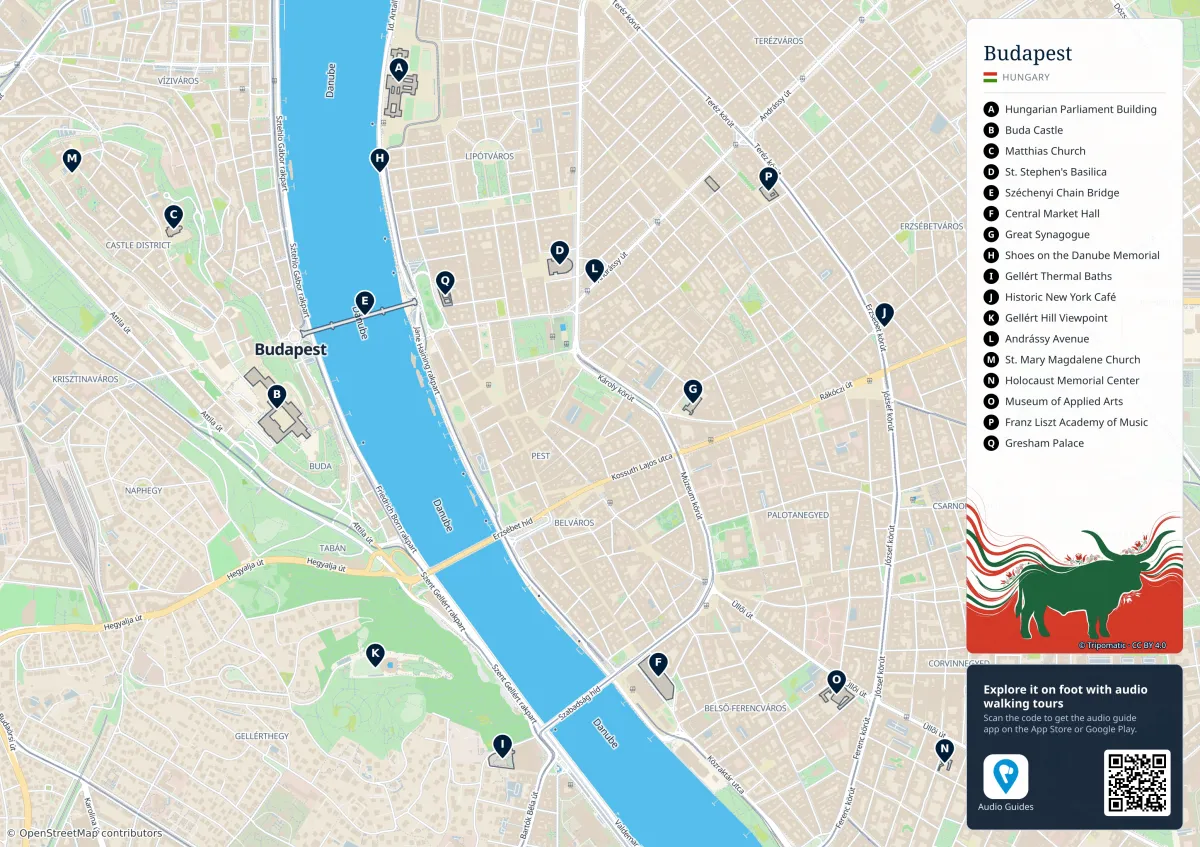
This street-based map covers central Budapest around the Danube, Castle Hill and inner Pest. It is a planning overview, not a live transport map. Outer neighbourhoods, the airport and parts of northern Budapest need additional coverage. The letters locate attractions; they do not indicate walking order or guarantee that a site is open.
Read the map before choosing a route
A is Parliament, B Buda Castle, C Matthias Church, D St Stephen’s Basilica, E Chain Bridge, F Central Market Hall, G the Great Synagogue and H the Shoes on the Danube memorial. The map also marks Gellért Bath (I): that is a location reference only. The operator says the bath is closed from October 2025, with reopening planned for 2028. Do not turn the printed label into an active bathing reservation.
The river runs broadly north–south through the central city. Buda is west of it and Pest east. A bridge line does not show the climb to Castle Hill: plan the approach separately, particularly with a wheelchair, pushchair or heavy luggage. The downloadable original keeps the street labels readable when the mobile preview is too small.
Which neighbourhood fits which task?
| Area | Useful for | Planning limitation |
|---|---|---|
| Castle District, I | Elevated viewpoints, Matthias Church and historic streets | Slopes, cobbles and works can complicate a simple-looking route |
| Belváros–Lipótváros, V | Parliament, the Pest waterfront and Basilica area | Long north–south walks accumulate |
| Terézváros, VI | Andrássy Avenue and Opera area | A district name does not mean every address is central |
| Erzsébetváros, VII | Jewish heritage, food and evening venues | Noise varies sharply by street and room orientation |
| Palace Quarter, VIII | National Museum area and a calmer base near central connections | Check the exact address, not a district stereotype |
| Újlipótváros, XIII | Residential cafés and access toward Margaret Island | Allow travel time to southern Pest |
| Újbuda, XI | Buda-side river walks and connections around Szent Gellért tér | The whole district is much larger than its riverside corner |
Build days from clusters
Keep Parliament, the nearby waterfront memorial and the Basilica on a Pest-oriented day. Put Matthias Church and Fisherman’s Bastion in the same Castle District block. The Great Market Hall and Liberty Bridge work as another compact pair, but adding City Park immediately afterwards requires a transport leg.
Do not read the map’s attraction letters as a suggested A-to-Q itinerary. Choose a start point near your accommodation, one timed booking and one flexible outdoor block. Itineraries gives workable day sequences; Getting Around explains tickets, transfers and late travel.
Using the map on a phone
Open the full-size image before you lose connectivity, then zoom into the part of town you need. Save the address of your accommodation separately. Static maps cannot show lift outages, construction fences, tram diversions or flood-related embankment restrictions. Check BKK’s current journey information before setting out.
For neighbourhood selection use Where to Stay. For step-free routes and the questions to ask a venue, use Accessibility. A marked attraction or bridge is not proof of a step-free approach.
Sources & planning updates
Practical information checked on 16 October 2026. Recheck opening times, temporary closures and the conditions for your travel date with the relevant operator.