
UNITED ARAB EMIRATES · DUBAI GUIDE
Palm Jumeirah Photography: Shape, Viewpoints and Light
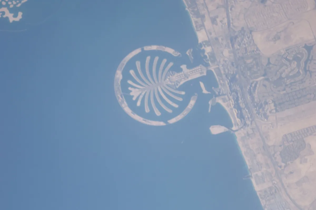
Palm Jumeirah looks very different from above and from its streets or waterfronts. An elevated view can explain the trunk, fronds and surrounding crescent; a ground-level photograph can show architecture, water and activity without revealing the whole outline. Decide which story you want before choosing a viewing ticket or making the journey.
The historical astronaut photograph at the top of this page illustrates the Palm's overall shape from orbit. It gives geographic context rather than a camera position available to ordinary visitors; an observation deck or a permitted ground-level view offers a different perspective.
Choose Between the Shape and a Ground-Level Scene
The View at the Palm offers an official elevated observation experience. Compare the actual level, entry product and time before booking, and follow the current visitor rules. It is a way to understand the Palm's geography, but it is not the same perspective as a photograph from an aircraft high above the coast.
Ground-level views serve a different purpose. Look for a permitted public area or an authorised hotel or restaurant visit that gives a coherent foreground and water relationship. Do not assume every beach, resort terrace or stretch of waterfront is open to anyone carrying a camera. Use Map & Neighbourhoods to understand the layout rather than treating a photograph as a navigation map.
Read Aerial Photographs Honestly
Published aerial images can come from aircraft or orbit; use the source to identify the perspective. An aircraft photograph can reveal the whole Palm while also showing haze, window reflections or part of the wing. Those details explain the conditions of the image and should not be removed from its meaning. A historical aerial view records development at its source date; it does not establish today's buildings, beaches or transport connections.
If you hope for a view on a scheduled flight, seat, route, direction, weather and air-traffic conditions can all change what is visible. It is not a guaranteed sightseeing product. Do not infer permission for private aerial work or drone flying from a published aerial image. Those activities have separate rules and approvals.
Simplify the Pattern and Work with Visibility
For an elevated composition, place the recognisable pattern where it can be read and avoid letting a bright window reflection dominate. A very wide angle can include more coastline while making the central shape small; a tighter frame can make the geometry clearer. Keep enough context to show what the image describes.
Haze reduces separation between water, land and the distant city. Check actual visibility instead of buying a particular time solely for the word sunset. Softer light can be attractive, but a clear daytime view may explain the form better than a dramatic sky with an indistinct foreground. Do not over-process colour or clarity until the scene suggests conditions that were not present.
Use Equipment That the Viewpoint Allows
The View's current terms restrict equipment that compromises safety or obstructs operations, and ticketed ledge experiences have their own conditions. Confirm your camera, tripod or planned shoot with the operator before arriving. A viewing admission is not automatic permission for a commercial setup or unrestricted time at one spot.
Keep space for other visitors at the glass, avoid leaning equipment against it and follow staff directions. If you are travelling with a group, take turns rather than blocking the view for a long session. Build the Palm visit into one coherent half-day or resort day using Itineraries, and use Photo Spots for other city scenes if visibility disappoints.
Travel Tip
Ask whether you want a recognisable Palm outline or a photograph made on the Palm. Those are different pictures and often need different viewpoints.
Sources and Current Checks
Editorial sources checked on 2 November 2026. Recheck live booking, operating and travel conditions for your dates.
Frequently Asked Questions
Can I see the whole palm shape from ground level?
Ground-level views usually describe parts of the island rather than its complete outline. An appropriate elevated viewpoint better explains the geometry.
Will The View reproduce an aircraft photograph?
No. The location, height and angle differ. Treat a scheduled-flight image as an aerial perspective, not as a sample of the exact observation-deck view.
Can I bring a tripod or fly a drone?
Check the viewing venue’s equipment rules and obtain any required permissions. Drone operation has separate rules; a published aerial photograph is not authorisation to fly.