
UNITED ARAB EMIRATES · DUBAI GUIDE
Dubai Map and Neighbourhoods: Understand the City Layout
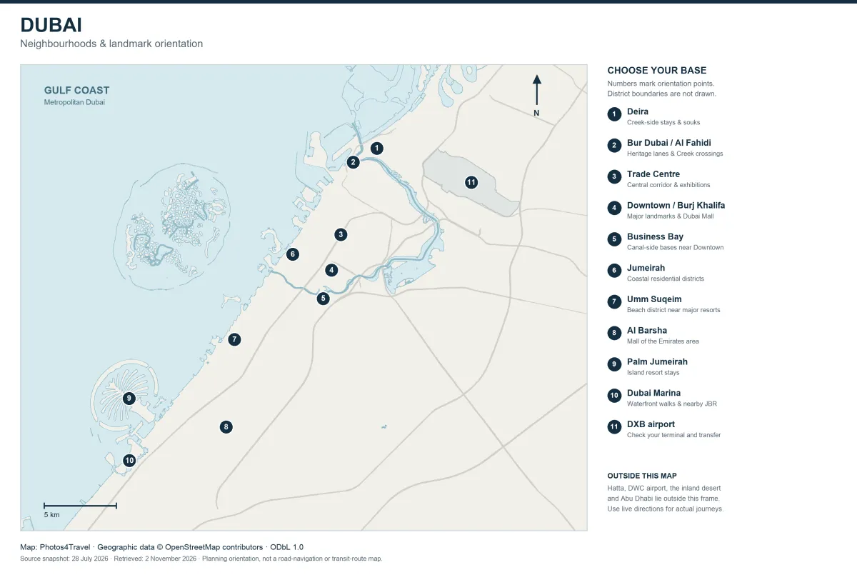
Dubai is a long coastal city with several distinct clusters rather than one compact sightseeing centre. Understanding the relationship between the Creek, the central corridor and the south-western waterfront helps you choose a realistic day and avoid repeatedly travelling between distant places.
The map below is an orientation map built from real OpenStreetMap geographic data. Selected numbered points help connect the place names used in this guide; they are not administrative boundaries, a live transport diagram or precise hotel locations. For the accommodation decision, continue to Where to Stay.
Read the Dubai Orientation Map
Use the coastline, water features and selected major roads to understand the broad layout. The numbered markers identify selected locations and clusters, not the full extent of each neighbourhood. The map covers the main urban corridor shown; it does not cover the whole emirate, all desert areas, Hatta or every airport connection.
The source data snapshot was retrieved for this guide on 2 November 2026 and carries its own data timestamp. OpenStreetMap contributors maintain the underlying geography, while the choice of labels is editorial. Open the high-resolution version to read small labels comfortably. Use a current journey planner for operational directions, crossings and transport rather than treating the static map as turn-by-turn navigation.
The full-resolution map opens in a new tab. Use your browser’s zoom to inspect labels. This orientation map does not show district boundaries or current transport routes.
Connect the Numbered Locations to Your Plan
On small screens, swipe or scroll this table horizontally. Keyboard users can focus the table area and use the arrow keys.
| Marker | Place | Why it matters |
|---|---|---|
| 1 | Deira | Creek-side trading streets, souks and city stays |
| 2 | Bur Dubai / Al Fahidi | Heritage lanes and the opposite bank of the Creek |
| 3 | Trade Centre | Part of the central corridor and exhibition area |
| 4 | Downtown / Burj Khalifa | Dubai Mall and major skyline attractions |
| 5 | Business Bay | Canal-side areas close to, but distinct from, Downtown |
| 6 | Jumeirah | Coastal residential districts rather than one single beach |
| 7 | Umm Suqeim | A coastal district near well-known resort and beach areas |
| 8 | Al Barsha | Mall of the Emirates area and surrounding city districts |
| 9 | Palm Jumeirah | Island resort areas with their own last-mile journeys |
| 10 | Dubai Marina | Waterfront district near the separate JBR seafront |
| 11 | DXB airport | Orientation only; check the exact terminal and transfer |
A marker is a reference point for the named area. It should not be used to estimate the walk to a particular entrance or identify the nearest station without a separate route check.
Read the Creek as Two Connected Banks
Deira and Bur Dubai sit on different sides of the Creek. A crossing can be part of the experience, but identify the relevant pier, bridge or transport connection for your exact route. Al Fahidi’s heritage lanes and the wider Al Shindagha museum district are related parts of a heritage day, not interchangeable names for the same entrance.
Build a manageable sequence: one bank, an appropriate crossing, a meal or museum and a return connection. A large roadside route can be a poor substitute for the short water crossing you actually intended. Things to Do explains the experience choices; the map helps place them in relation to one another.
Distinguish the Central Corridor from the Coast
Trade Centre, Downtown and Business Bay can appear close in a broad view, yet each visit still needs an entrance and last-mile plan. A Metro station, an observation-deck entrance and a hotel reception may sit on different parts of the same large development. Waterways and major roads can also shape the usable pedestrian route.
Jumeirah and Umm Suqeim describe coastal areas, not an automatic right to enter every resort or beach facility. Palm Jumeirah is a separate island layout, while the Marina and JBR combine waterside and seafront settings. The map makes those broad relationships visible; Beaches distinguishes public coast, managed park and paid facility choices.
Turn the Map into a Workable Day
Choose a cluster and one or two priorities, then check the real route for your travel time and mobility needs. Add the station-to-entrance walk, security, queues, meal and rest time. Do not turn a straight line or road distance into an invented door-to-door duration.
For a far-flung reservation, decide how you will return before filling the rest of the day. DWC and Hatta require separate planning beyond this urban map’s coverage. Use Getting Around for daily modes, Airports & Transfers for terminal arrivals and Day Trips for an out-of-city outing.
Travel Tip
Use the static map to choose the cluster, then use a current journey planner to choose the actual route. Check the destination’s entrance and the return journey as carefully as the outward trip.
Sources and Current Checks
Editorial sources checked on 2 November 2026. Recheck live booking, operating and travel conditions for your dates.
Frequently Asked Questions
Does this map show exact neighbourhood boundaries?
No. The numbered markers are selected orientation locations. They do not define an administrative district or the full extent of an area.
Is it a live Metro map?
No. It shows selected real geography for orientation. Use RTA’s current map and planner for services, stations, timetables and operational changes.
Is Dubai Marina the same as JBR?
No. Marina is a waterside district and JBR has the nearby seafront. Check the actual walking or transport connection between your chosen places.
Can I use the map for a Hatta day trip?
This urban orientation map does not cover the whole emirate or the Hatta route. Use the dedicated day-trip and current route information for that journey.