
AUSTRIA · VIENNA GUIDE
Vienna Map & Neighbourhoods: Find Your Bearings
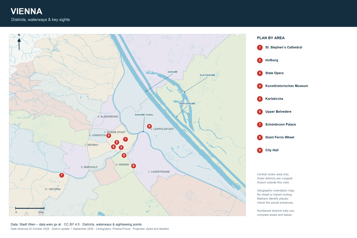
This orientation map uses Vienna’s real district boundaries, water geometry and sightseeing coordinates from the City of Vienna’s open geodata. It covers the central and inner western/eastern visitor areas, including Schönbrunn and the Danube side. It is a geographic planning map, not a live street, transit or accessibility map; the outer city is cropped and Vienna Airport lies outside this view.
Open the full-size Vienna map (3000 × 2000)
Read the City Before Planning the Day
The first district, Innere Stadt, is the dense historic centre. The Ringstrasse follows its edge; the Danube Canal is on the northeastern side. The main Danube, New Danube and Old Danube are farther northeast and should not be confused with the canal beside the centre. Schönbrunn lies west of the main central sightseeing area, while the Belvedere is to the south/southeast.
Those relationships explain why one central walk can connect several places, while a palace-and-Danube combination involves a more substantial journey. The numbered sight markers use the municipality’s supplied locations. They identify the place rather than a guaranteed visitor entrance. Use the operator’s information for the actual door and current access.
Neighbourhoods and Their Different Jobs
| Area | How it fits the visit | Useful next step |
|---|---|---|
| Innere Stadt (1) | Cathedral, Hofburg and dense central walking | Choose the interior visits |
| Leopoldstadt (2) | Prater and a route toward the Danube side | Compare outdoor plans |
| Landstrasse (3) | Stadtpark/Wien Mitte side and Belvedere access | Check the current airport connection |
| Wieden (4) | Karlsplatz, cafés and a south-side base | Compare accommodation areas |
| Mariahilf / Neubau (6 / 7) | Shopping, museum-quarter edges and neighbourhood evenings | Plan a purposeful shopping route |
| Hietzing / Schönbrunn side | A separate palace-and-garden block | Plan the estate visit |
Turn Geography into a Manageable Route
For a central half-day, group Stephansplatz, Michaelerplatz and a selected Hofburg visit. For the south side, combine Karlsplatz with Wieden or a Belvedere visit. For the west, give Schönbrunn a substantial block rather than treating it as a quick extension of the old centre.
The map does not show today’s U-Bahn or S-Bahn operations. In particular, the current 2026–27 airport works change familiar CAT and S7 journeys. Check Getting Around and Airports & Transfers for live-planner sources. A line or proximity on a geographic map is not evidence of a direct service.
Access and the Final Approach
A marker does not tell you whether the approach has cobbles, slopes, steps or a working lift. Use the accessibility resources and each venue’s actual entrance details. At a large estate, choose the gate and path before leaving your hotel; arriving at the opposite side can add significant walking.
Open the full-size map to read smaller district labels. On a phone, use it to understand relationships, then use a current journey planner or street map for the final route. Do not navigate a crossing or cycle route while looking only at this static image.
Map Sources and Scope
Data: City of Vienna district boundaries, municipal sightseeing points, flowing waters and standing waters, retrieved 20 October 2026. District records report an update of 1 September 2026. Cartography: Photos4Travel; data source: Stadt Wien – data.wien.gv.at, CC BY 4.0. Geometry was projected, styled, cropped to the visitor area and labelled in English; this is not a municipal endorsement.
Street-by-street navigation, service status, temporary closures, accessibility and the airport are outside the map’s scope. Use the linked official operators for those decisions.
Frequently Asked Questions
Does this map include Vienna Airport?
No. The airport is outside this central visitor-area view and outside the Vienna core fare zone.
Is the Danube Canal the same as the Old Danube?
No. They are different waterways in different parts of the city. Choose the actual waterside area before planning the route.
Can I use the markers as exact entrances?
Use them for orientation. Check the institution’s current visitor entrance and any special access arrangement separately.