NORWAY · OSLO GUIDE
Oslo Map & Neighbourhoods: Where to Stay & Explore
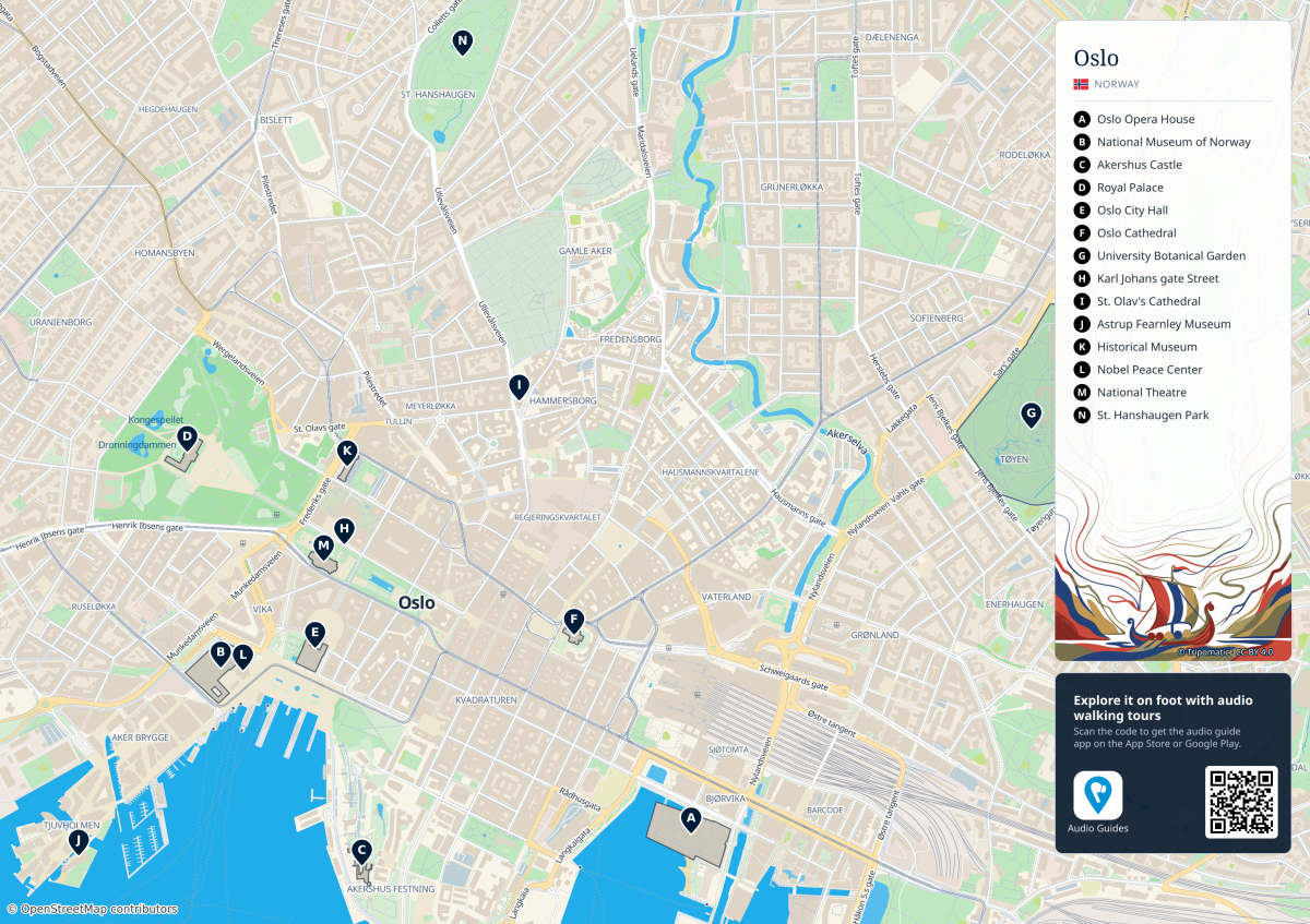
Oslo is easiest to understand as a compact centre opening onto the fjord, with residential neighbourhoods rising behind it. Choose a base by the places you will use every day: Oslo S for rail arrivals, the traditional centre for a first sightseeing visit, Grünerløkka for cafés and independent shops, or the western neighbourhoods for park time and a more residential setting. The best choice depends on the actual street and transport connection, as well as the district name.
Checked 18 October 2026. The district comparisons and walking times below are editorial planning guidance. Hotel availability, building access and transport operations need checking for your dates. These visitor areas overlap and do not reproduce Oslo’s administrative borough boundaries; VisitOSLO also uses a visitor-focused neighbourhood classification.
How to Read the Oslo Map
The real geographic map above is by Tripomatic, using OpenStreetMap data. Open the 3,104 × 2,192-pixel full-size version for street names and the legend, especially on a phone. The inline image is an overview; zoom the full-size file for detail. The labels are lettered A–N, not a suggested visiting order. A marks the Opera House; C, Akershus Castle; D, the Royal Palace; J, Astrup Fearnley Museum; and G, the Botanical Garden.
Use three anchors: the fjord is at the bottom, Oslo S and Bjørvika are in the southeast, and the Palace is west of the central shopping streets. Follow the Akerselva north to understand the relationship between central Oslo, Vulkan and Grünerløkka. On this sheet, Grønland lies east of the station area and Tøyen’s garden is farther northeast.
The map’s central frame includes the Palace, harbour, Grünerløkka and St. Hanshaugen, but does not cover all the western neighbourhoods, Frogner Park, Majorstuen, Bygdøy, Ekeberg, the islands, forest or airports. The large right-hand legend also covers part of the eastern street detail. Use the district notes and live street-level directions for those places. This is an orientation map, not a live transport map; a visible street does not establish an open gate, step-free route or current service.
Where to Stay in Oslo: Choose Your Base
| Your priority | Start your search here |
|---|---|
| First short visit | Sentrum / Nationaltheatret |
| Rail arrival or early train | Oslo S / nearby Bjørvika |
| Waterfront and art | Aker Brygge / Tjuvholmen |
| Cafés and evening outings | Grünerløkka / Vulkan |
| Park walks and local streets | Frogner / Majorstuen |
| Longer apartment stay | Compare Tøyen, St. Hanshaugen and outer residential streets |
For a first visit of one to three nights: compare the centre around Nationaltheatret with Oslo S before extending the search. These bases reduce repeated cross-city journeys, but a courtyard room and a room above a busy late-night street can feel very different. Choose the room, not just the postcode. The waterfront is attractive for an art-led trip, although an address deep into Tjuvholmen adds a final walk from the main rail network.
For families: prioritise usable room space, a lift, breakfast or cooking facilities, a grocery shop and the route to your first activity. Frogner’s park access can be useful, while Bjørvika works for waterfront museums and play stops; neither is automatically the right family choice. Check the actual walk with a stroller, including station exits, bridges and any steps.
For value: compare total stay cost on the same dates and room terms. A less central apartment may add local fares, cleaning charges and travel time; a higher-priced central room may save journeys. Do not assume that Grønland, Tøyen or any other whole district always has cheaper accommodation. For named properties, verified hotel photographs and direct booking options, use Oslo Hotels; this page helps choose the area.
Important Oslo Neighbourhoods
Oslo S, Bjørvika and Sørenga: Arrival and Modern Waterfront
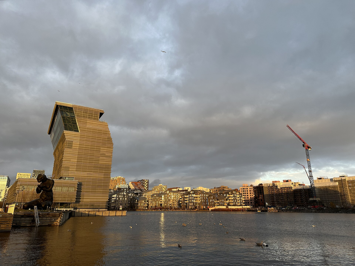
Oslo S is the main rail arrival point; Jernbanetorget is the adjoining public-transport hub. South of the tracks, Bjørvika brings together the Opera House, Deichman library, Barcode, MUNCH and the newer streets of Oslobukta. Sørenga extends the waterfront walk farther south. VisitOSLO’s Bjørvika guide is useful for understanding this redeveloped harbour area.
Stay here for: a short visit with luggage, an early rail departure or architecture and museum time. Check which side of the station the accommodation is on: the northern bus-terminal side and the southern waterfront have different approaches. A harbour-view apartment farther along the waterfront is not necessarily a short luggage walk from the train.
Connections and time: use Oslo S/Jernbanetorget for the main interchange, or check Bjørvika’s tram/bus stops for the exact address. Allow roughly 2–4 hours to explore the waterfront with a stop; a full museum visit is additional. Broad open spaces can be windy, so a waterside walk and a sheltered route back are both useful.
Sentrum, Karl Johans Gate and Tullinløkka: The First-Visit Centre
The traditional centre runs between Oslo S and the Royal Palace along the Karl Johans gate axis. Nationaltheatret anchors its western end; Stortinget is useful for the middle. Tullinløkka, north of the main street, offers another pocket of cafés, cultural stops and evening choices. These are convenient places to begin if you want several sights within one walking day.
Stay here for: a first visit with limited time, central dining or a mix of harbour and Palace-area walks. Busy shopping and entertainment streets are part of the appeal, but ask about glazing, room orientation and nearby construction if sleep is a priority. “City centre” covers a large enough area that the nearest station still matters.
Connections and time: compare Nationaltheatret, Stortinget and Jernbanetorget against the actual entrance. A 1–2-hour orientation walk works well before adding an attraction. Read the official city-centre guide for the relationship between the smaller central districts.
Kvadraturen and Akershus: Historic Streets Between Station and Harbour
South of Karl Johans gate, Kvadraturen’s regular street grid leads towards the fortress and waterfront. This is a useful geographical bridge between Bjørvika and City Hall, with historic buildings, galleries and smaller streets rather than one continuous shopping promenade.
Stay here for: a central position that lets you choose a harbour route or a station route on foot. Check the surrounding block after dark and the distance to your preferred restaurants; a quieter-looking daytime street is not proof of a quiet room. Connections: compare the walk to Jernbanetorget or Stortinget. Allow about 1–2 hours for a neighbourhood loop; fortress interiors, museums and access-controlled grounds need their own time and opening checks.
Aker Brygge and Tjuvholmen: Harbour, Dining and Contemporary Art
West of City Hall, Aker Brygge’s waterfront continues towards the smaller islands and channels of Tjuvholmen, home to Astrup Fearnley Museum. It is a good area for an unhurried meal and harbour walk. Use the official Aker Brygge/Tjuvholmen guide to identify the different waterfront pockets.
Stay here for: waterfront atmosphere and an art-led trip, accepting the final walk back from the main stations. Compare room outlook and evening restaurant noise, rather than paying for a generic “harbour” label. Connections: Nationaltheatret is a useful rail/metro approach, with Aker Brygge’s local stops and boat departures serving specific journeys. Check the pier named on your ticket: Rådhusbrygge and Aker Brygge departures are not one interchangeable boarding point. Allow roughly 1–2 hours for the promenade, plus a museum visit or meal.
Frogner and Majorstuen: Residential West and Park Access
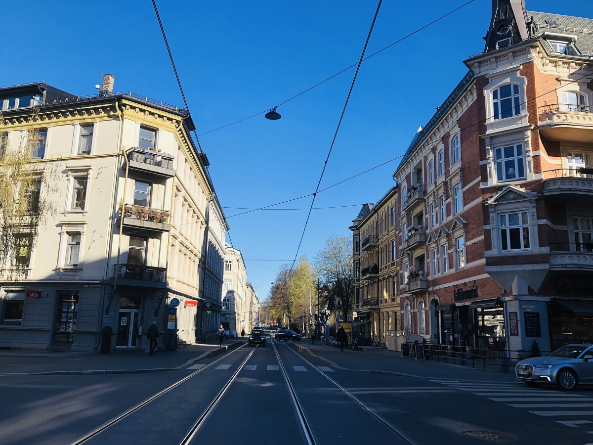
These western neighbourhoods lie beyond most of the map’s frame. Majorstuen is the transport and shopping focus reached along the Bogstadveien/Hegdehaugsveien corridor from the Palace area. Frogner has residential streets, cafés and access to Frogner Park and the Vigeland installation. They are useful alternatives when neighbourhood time matters as much as the waterfront.
Stay here for: a slower visit, park walks or a longer stay with everyday shops. Compare the route from the property to the park entrance you plan to use; a Frogner address does not put every hotel beside the sculpture garden. Older buildings may have entrance steps or small lifts, so check the accommodation itself.
Connections and time: Majorstuen is a major T-bane interchange; for Frogner, choose the tram/bus stop appropriate to the street, with Frogner plass or Vigelandsparken useful search terms for park-side journeys. Allow 2–3 hours for a combined neighbourhood and park outing, longer for museums. The Oslo West guide explains the shopping corridor and nearby residential areas.
Grünerløkka: Cafés, Independent Shops and River Walks
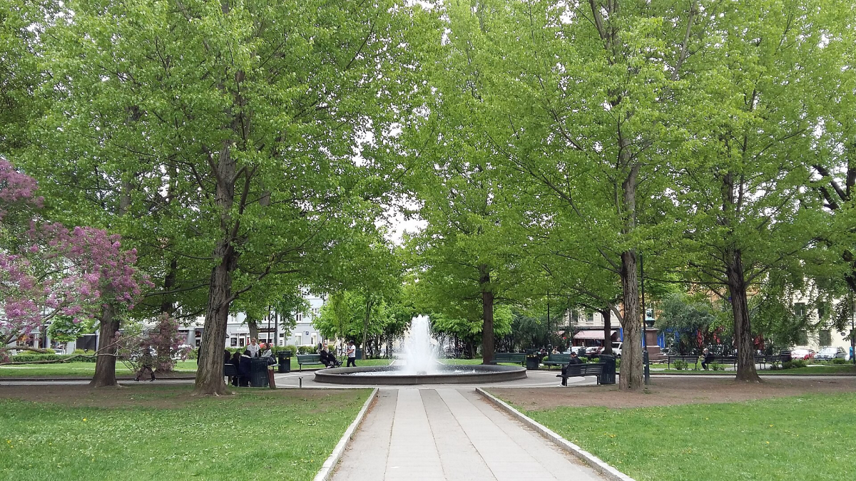
North of the centre and east of the Akerselva, Grünerløkka is a good choice for browsing rather than ticking off major monuments. Thorvald Meyers gate and Markveien form useful shopping and café corridors; Olaf Ryes plass and Birkelunden give you recognisable meeting points. Parks and river paths make it easy to alternate shops with time outdoors.
Stay here for: coffee, independent shopping and an evening in the neighbourhood. A lively street can be convenient for going out, while a side-street apartment may suit a different routine; check the specific room and late return. Connections: look for a tram to Olaf Ryes plass or Birkelunden and compare the final walk. This area is not served by a metro station at every main square. Allow about 2–3 hours for a relaxed loop, with shopping and meals extending it. See VisitOSLO’s Grünerløkka guide and our shopping advice.
Vulkan, St. Hanshaugen and Bislett: River Edge and Local Routines
Vulkan sits beside the Akerselva between Grünerløkka and the higher streets of St. Hanshaugen. It is a compact food and cultural pocket around Mathallen. Farther west, St. Hanshaugen’s hill park and the streets towards Bislett are useful for a neighbourhood-led visit; the park is shown as N on the map.
Stay here for: repeated café, grocery and park routines on a longer visit. Check the slope and the exact approach if you have luggage or need step-free access. Connections: Vulkan’s own arrival guide identifies Telthusbakken as a bus approach and Olaf Ryes plass as a tram approach, with a bridge from Nordre gate. It also describes stairs from the Maridalsveien/Fredensborg side: choose another confirmed approach if steps are a problem. Allow 1–2 hours for the river/food-hall area, with separate time for the hill park.
Grønland, Tøyen and Kampen: East-Side Everyday Oslo
Grønland is east of the central-station area, with food shops and a varied restaurant scene. Continue northeast towards Tøyen for the Botanical Garden and Natural History Museum, or farther east towards Kampen’s wooden-house streets. These make a different day from the western harbour and should be grouped as an east-side outing. VisitOSLO’s Oslo East guide explains the relationship.
Stay here for: an apartment-led trip or easy access to local food shopping, after comparing the exact building and connection. Check the return route and luggage approach as you would elsewhere; district labels alone do not establish value, noise or accessibility. Connections: Grønland and Tøyen are T-bane stations; Kampen adds a walk or local connection depending on the address. Allow roughly 2–4 hours for an east-side loop with a garden stop, longer for the museum. The old Munch Museum site at Tøyen is not the current MUNCH museum, which is in Bjørvika.
Gamlebyen and Ekeberg: Older History and Higher Viewpoints
Gamlebyen is the medieval-city area east of Bjørvika, distinct from Kvadraturen’s later historic grid. Ekeberg rises farther southeast, with sculpture-park walks and viewpoints. The climb and the separation from the central harbour are the practical points when you draw a route.
Stay here for: a specific residential setting or repeated access to this side of the city, after checking the connection to the rest of your plans. Connections: use the live planner for Gamlebyen’s stops or Ekebergparken, rather than treating an uphill park walk as a short extension of every waterfront visit. Allow 2–3 hours for a focused outing; choosing one area is easier than rushing both. Neither should be navigated from the small central map alone.
Transport Links Between Neighbourhoods
| Area | Useful starting point |
|---|---|
| Oslo S / Bjørvika | Oslo S rail; Jernbanetorget hub; Bjørvika local stops |
| Central west | Nationaltheatret rail/metro; Stortinget metro |
| Frogner / Majorstuen | Majorstuen metro; park-side tram/bus stops |
| Grünerløkka | Olaf Ryes plass / Birkelunden tram stops |
| Vulkan | Telthusbakken bus; Olaf Ryes plass plus walk |
| Grønland / Tøyen | Grønland / Tøyen metro stations |
| Harbour departures | Exact Aker Brygge / Rådhusbrygge pier on the ticket |
These are orientation points, not guaranteed direct services. Enter the actual accommodation or attraction address in Ruter’s journey planner and compare the departure time, changes, walking legs and station exit. A route that is quick between platforms may still be awkward with bags. Use the official network maps for the transport network; the tourist map above has a different purpose.
Works affecting your base: Ruter’s metro-upgrade notice announces a near-network-wide closure on 19–22 November 2026, with reduced capacity on the alternatives. It also lists planned 2027 closure periods, including 12–15 August, overlapping Øya. Dates and replacement arrangements can change. For these trips, compare accommodation with a useful walking or tram/bus alternative instead of relying only on a nearby metro entrance.
For current ticket options, zones and night-service advice, see Getting Around. For the final connection after Gardermoen or Torp, use Airports & Transfers. Check a late return separately if you plan an evening in Grünerløkka or another district; Nightlife gives more detail.
Walkable Combinations Without Crossing the City Repeatedly
- Eastern waterfront: Oslo S → Opera House/Deichman → MUNCH/Oslobukta. Add Sørenga only if weather, time and the chosen crossing suit you.
- Historic centre to west harbour: Kvadraturen → Akershus surroundings → City Hall → Aker Brygge/Tjuvholmen. Check fortress gates rather than assuming every path is a through-route.
- Cafés and river: Olaf Ryes plass/Grünerløkka → Akerselva → Vulkan. This makes a compact outing; St. Hanshaugen adds an uphill leg.
- Western park day: Majorstuen or a park-side stop → Frogner Park → nearby residential streets. Treat the journey from the harbour as a separate leg.
The neighbourhood visit times above are approximate blocks including browsing and pauses, not measured point-to-point journeys or opening guarantees. For a complete sequence with museum durations and alternatives, use the 1-, 2- and 3-day itineraries and Attractions.
Longer Stays: Choose for Everyday Life
For a week or more, compare usable kitchen equipment, laundry, groceries, workspace, cleaning charges and cancellation terms. Ask whether a kitchenette actually has the appliances and cookware you need. Check Wi-Fi and a practical table if you expect to work, rather than inferring them from an attractive room photograph. Permission to work or remain in Norway is a separate question from being able to book an apartment.
Grünerløkka/Vulkan suits a food-and-café routine; Frogner or St. Hanshaugen can suit repeated park and neighbourhood walks; Tøyen can be practical for an east-side routine with the metro. These are starting points for comparing real addresses, not promises about every apartment. Check lift dimensions, entrance steps, the hill from the stop and the journey during any planned works. Ask the property directly about the room and building conditions that affect your stay.
Beyond This Map: Bygdøy, Islands and Forest
Bygdøy is a peninsula with a distinct museum outing, not an island you can reach on any harbour ferry. The Oslofjord islands use particular piers and seasonal timetables. Holmenkollen and Sognsvann require their own outward and return plans. None is fully represented on this central street map, so use live directions and leave enough time beyond the city-centre walking blocks. Our Parks & Outdoor Activities and Beaches Near Oslo pages help choose an outing.
Map source and reuse terms: Tripomatic; geographic data: OpenStreetMap contributors. District and transport sources are linked beside the relevant advice. Conditions checked 18 October 2026; confirm the current route and property details for your dates.