

Sign in
For Photos4Travel editors and team members.
USA · LAS VEGAS GUIDE
Las Vegas Map & Neighbourhoods: Strip, Downtown & Beyond
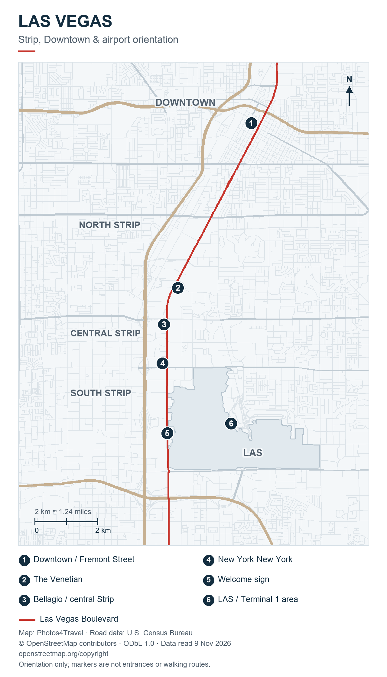
Read Las Vegas as several connected areas, not one continuous row of attractions. The Strip, Downtown, the Arts District, the airport and off-Strip destinations need different journeys. This guide explains their relationship so that you can choose a base and group each day's plans sensibly.
The orientation map above marks six reference points, explained in the key below. It shows the relationship between Downtown, the Strip and LAS rather than every hotel, entrance or transport stop. Central, south and north Strip are practical planning labels, with no official district boundary implied.
Understand the map before building a route
Read the numbered map from north to south: Downtown/Fremont is point 1; The Venetian is 2; Bellagio and the central Strip are 3; New York-New York is 4; and the Welcome sign is 5. Airport reference point 6 lies southeast of the resort corridor. The gaps between these points are journeys to plan, rather than extra sights on one continuous resort walk.
For the full geographic picture, compare the official Las Vegas maps with your booked hotel's address. A map point marks a property, not necessarily its public entrance, pickup point or the shortest accessible route through it.
Las Vegas areas and how to use them
On smaller screens, swipe or scroll horizontally to read the full table.
| Marker | Reference point | Use it to plan |
|---|---|---|
| 1 | Downtown / Fremont Street | A Downtown museum-and-evening outing, with a separate Strip transfer |
| 2 | The Venetian | The canal and resort setting, with nearby northern and central Strip choices |
| 3 | Bellagio / central Strip | A base for comparing Bellagio, Paris and Caesars Palace plans |
| 4 | New York-New York | The south Strip resort corridor; Luxor and Mandalay Bay lie farther south |
| 5 | Welcome sign | A separate south-end photo stop; combine it with a planned nearby outing |
| 6 | LAS / Terminal 1 area | Airport orientation only; use the correct terminal’s official pickup map |
The Strip: choose a section
Use points 2 and 3 to compare a Venetian/LINQ outing with a Bellagio/Paris/Caesars outing. Point 4 begins a different southern cluster around New York-New York, Excalibur and Luxor. Choose the cluster containing your fixed booking, then decide whether another area adds enough interest to justify a transfer.
The Monorail map adds a different layer: its stations run along the east side of the resort corridor between MGM Grand and SAHARA. It does not join airport point 6 or Downtown point 1, and it does not extend south to every resort beyond New York-New York. Use the geographic map for orientation and the operator map for a station-to-station journey.
Use Where to Stay for an accommodation decision and Getting Around for the actual connection. This page provides the geography behind those choices.
Downtown and the Arts District
Downtown has several distinct parts. The Fremont Street canopy is a well-known entertainment focus, while Fremont East offers another set of bars, dining and streets. The Arts District has its own galleries, murals, shops and food stops. The City Downtown guide explains these areas without treating them as the same place.
Check the entrance and programme for a museum visit, then decide what fits around it. A map that groups two museums under Downtown does not tell you that both belong in a short morning. The Downtown Loop route may help connect selected stops when it is operating.
Airport and off-Strip stops
For LAS, begin with the airline's terminal and the pickup instructions for your transport service. The current airport terminal maps serve a different purpose from the city map: they help you reach the correct baggage, shuttle or garage level.
Off-Strip attractions should be checked individually. For example, Omega Mart is inside AREA15 at South Rancho Drive; it is not an exhibition inside a central Strip resort. Include the journey and the return when fitting it into an itinerary.
Putting day trips in perspective
Use a regional map for the desert and canyon destinations. A small marker outside Las Vegas does not establish that a place is a short drive, that every road is open or that the return fits before an evening show. Identify the exact park entrance or visitor location, then check the current operator or land-manager instructions.
Start with the day-trip guide and add one outing that suits the available day. Red Rock Canyon's Scenic Drive, for example, has seasonal hours and timed-entry arrangements described by the Bureau of Land Management.
Turn the map into a workable itinerary
- Mark your accommodation and fixed reservations.
- Group nearby attractions around each reservation.
- Check the actual entrances and pedestrian routes.
- Choose transport for the gaps between groups.
- Add meal, rest and weather alternatives before booking more stops.
Save the address and booking information for important stops before leaving the hotel. When access changes, use current signs and the venue's directions rather than an older screenshot. Our itineraries demonstrate this area-based approach.
Travel TipSave the hotel pedestrian entrance and pickup point as separate places. Using the right point is particularly helpful when a large resort has several roads, garages and entrances.
Frequently asked questions
Are Downtown and the Strip the same place?
No. They are distinct areas. This guide recommends planning a separate journey between them and grouping each outing locally.
Does a hotel map marker show its main entrance?
Not necessarily. Check the specific entrance for hotel reception, a show, parking or ride pickup, especially at a large resort.
Can I use the Monorail map to plan every journey?
No. It shows the Monorail corridor and stations, not the full city or all other transport services. Check a geographic map and the operator for the journey you need.
Where should I stay to reduce travelling?
Choose an area near the destinations you will revisit, particularly in the evening. Compare the alternatives in Where to Stay.
Will an old Strip map still be useful?
It may show historical geography but can contain former hotel names, closed attractions or changed routes. Use a current map and verify the stops you intend to visit.
Tours, Tickets & Experiences
Las Vegas Travel Tips & Inspiration