
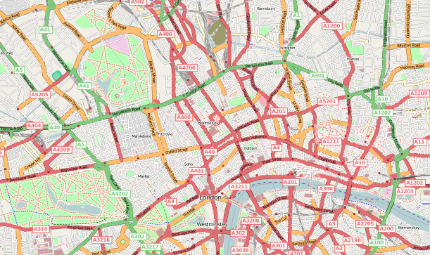
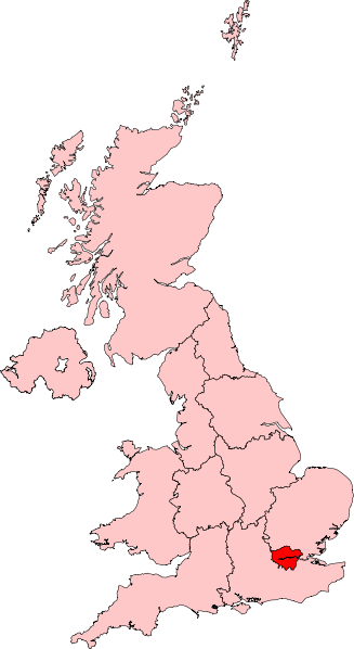
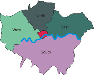
Map of London
Map of London
London is easiest to navigate when you think in clusters along the Thames and around major rail hubs. The central sightseeing area is only one part of Greater London, and districts that look close on a map can involve a long walk or a change between Underground lines.
Westminster and the West End
Westminster sits beside the Thames and contains Parliament, Westminster Abbey and the ceremonial centre around Whitehall and Buckingham Palace. North and east of it, the West End includes Soho, Covent Garden, Leicester Square and much of the theatre and shopping district. Walking between nearby sights is often practical, though crowds and crossing times matter.
South Bank and Southwark
Across the river from Westminster, the South Bank links riverside cultural venues, bridges and views toward the City. Farther east, Southwark includes Borough Market, historic streets and routes toward Tower Bridge. A riverside walk is a useful way to connect landmarks without repeatedly going underground.
City of London and the East
The City is London’s historic and financial core. St Paul’s Cathedral, the Bank area and Leadenhall Market sit among contemporary offices. Shoreditch lies northeast of the City and is known for food, nightlife and creative businesses. Canary Wharf is farther east in the Docklands; the DLR and Elizabeth line make it straightforward to reach, but it is not next to the West End.
West and north neighbourhoods
Kensington and South Kensington are useful for museums, garden squares and Hyde Park. Chelsea lies to the south, while Notting Hill is west of the park and best approached through its own Underground stations. Camden is north of central London, with markets and canal walks. Choose a destination station by the actual attraction entrance, not only by the neighbourhood label.
Greenwich and the river
Greenwich is part of London, southeast of the centre. It combines the Royal Observatory, the park, maritime sites and riverside connections. DLR, rail, boat and bus routes provide different approaches; it is an excursion across the city rather than a separate day trip from London.
Major rail stations
Paddington serves routes toward western England and Heathrow connections; Victoria handles many southeast services and Gatwick trains; King’s Cross and St Pancras connect to northern England and international Eurostar services; Euston serves the northwest; Waterloo connects to southwest England; Liverpool Street serves eastern routes and Stansted links. For schedules, use National Rail and operator information.
Reading the map and transport zones
TfL’s fare zones are useful for calculating many rail journeys, but they are not neighbourhood boundaries and not every service uses the same fare rules. Zone 1 covers much of the central sightseeing area; outer zones extend far beyond it. Heathrow is in Zone 6 for Underground and Elizabeth line fare purposes, while airport express services use separate ticket products. Consult current TfL maps and fare information before buying passes.
Walking distances can surprise visitors
Covent Garden, Leicester Square and Soho are close enough to combine on foot. By contrast, “Kensington” covers a broad area and a museum can be a significant walk from the nearest station entrance. At major interchanges, reaching the correct platform may take several minutes. Use an accessible route planner if stairs or long corridors are an issue.
Stations as orientation points
| Cluster | Useful starting station | A sensible nearby grouping |
|---|---|---|
| Westminster | Westminster | Parliament Square, Westminster Bridge and St James’s Park |
| West End | Charing Cross or Leicester Square | Trafalgar Square, National Gallery and Covent Garden |
| Bloomsbury | Holborn or Russell Square | British Museum and nearby squares |
| South Kensington | South Kensington | V&A, Natural History Museum and Science Museum |
| Tower area | Tower Hill | Tower of London, Tower Bridge and the river |
| Southwark | London Bridge | Borough Market and the south-bank route |
| Greenwich | Cutty Sark DLR or Greenwich rail | Town centre, riverside and Greenwich Park |
These are orientation choices, not a guarantee of step-free access or the closest entrance. Use TfL's street and accessibility maps for the exact station exit and venue approach.
Airport and rail arrival orientation
Heathrow lies west of the city, Gatwick south, Stansted northeast, Luton north and London City east. Each has its own rail or public transport connection. Mainline stations are spread around the centre rather than concentrated in one terminal. If you arrive at one station and depart from another, leave time for travel across town, luggage handling and the possibility of disruption.
Useful map layers
For a trip, keep a street map, TfL Underground and rail map, and accessibility map available. A Tube schematic prioritizes connections over geographic distance, so it can make nearby surface locations look far apart or distant areas seem close. For walking, use a street map and check pedestrian crossings. For cycling, choose a cycling layer that shows designated routes.
Download current TfL Tube, rail, bus and accessibility maps, or use Visit London’s official map guide. The images on this page help with broad orientation; current operator maps should determine your transport route.
- Street map: choose the entrance, bridge and walking route between sights.
- Rail map: identify the line and interchange, then check live service information.
- Accessible route: check both station access and the final street approach; a step-free station alone does not guarantee the whole journey.
Plan a daily cluster
For a compact west-to-east riverside route, start at Westminster, cross Westminster Bridge and walk towards the Southbank Centre. Waterloo is a useful shorter finish; extending to Tate Modern adds an indoor visit and a finish near Blackfriars. Keep the Tower area for another day if you want substantial time inside both an attraction and a museum.
For the City, use St Paul's–Bank–Monument–London Bridge as a separate architectural route. A transport diagram shows connections; a street map shows the streets and river crossings needed for the actual walk. Detailed example days are in the main London guide.
Use a map when a district name is broad
“Central London” can refer to different areas depending on the speaker. If a hotel listing says it is central, check its walking distance to a named station and the actual line serving your sights. Likewise, “near Hyde Park” or “near the river” may still mean a long walk to a particular entrance. Use the property address, not marketing language, to assess the location.
Related London guides: Hotels in London; London Transportation Guide; London attractions.
Research and update: Photos4Travel planning guide, updated 30 September 2026. Official visitor, venue and transport sources are linked where relevant. Suggested routes and visit allowances are editorial planning examples; live schedules, menus and access conditions come from the linked providers.