
User login
Map of Cuba
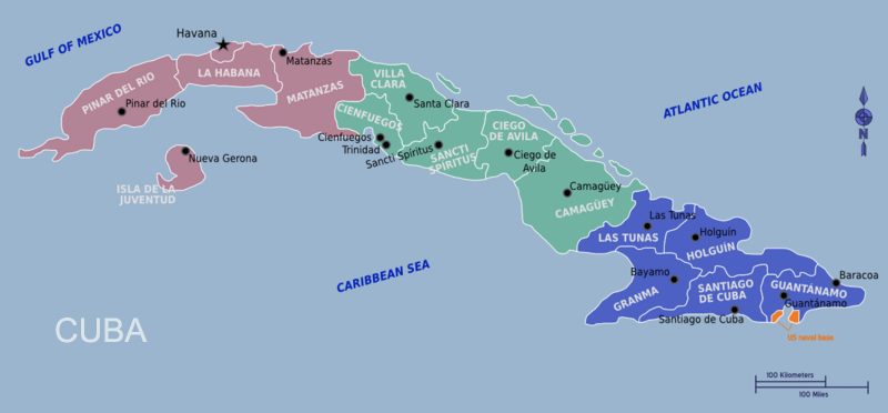
Cuba is the largest island in the Caribbean and stretches across more than 1,200 kilometers of coastline. Its long, narrow shape, archipelagos, and surrounding cays create a geography that is both visually striking and important for travelers planning routes. This map provides a clear overview of Cuba’s main regions, major cities, transportation corridors, and coastal areas, helping visitors navigate the island with confidence.
Before planning your itinerary, it’s helpful to combine this map with essential background information in the Cuba Travel Guide.
Geographic Orientation
Cuba is part of an extensive archipelago that includes the main island, Isla de la Juventud, and thousands of smaller keys known as cayos. The island’s geography transitions from western tobacco valleys to central colonial cities and eastern mountains.
- North Coast: Facing the Atlantic Ocean, known for beaches, cayos and major resort areas
- South Coast: Borders the Caribbean Sea, dotted with bays, coral reefs and historic towns
- West: Home to Viñales Valley and agricultural landscapes
- Central: Features colonial heritage cities such as Trinidad and Cienfuegos
- East: More mountainous terrain, Afro-Caribbean cultural centers and Santiago de Cuba
Main Cities on the Map
These major urban centers appear on most Cuba maps and serve as key travel hubs:
- Havana: Capital city on the northwest coast; cultural and historical heart of Cuba
- Santiago de Cuba: Eastern capital known for music, festivals and Afro-Caribbean heritage
- Camagüey: Central Cuba’s labyrinth-like colonial city
- Holguín: Eastern regional hub close to resort coastlines
- Cienfuegos: Southern port city with French-inspired architecture
- Trinidad: UNESCO colonial masterpiece near mountains and beaches
If you’re planning which cities to visit first, the upcoming Top Destinations in Cuba page will offer a curated overview.
Coastal Regions & Island Groups
Cuba’s coastline is one of its greatest assets. Travelers will see the following regions highlighted on most maps:
- Varadero Peninsula: Major resort area on the north coast
- Jardines del Rey: Cayo Coco, Cayo Guillermo and other northern keys
- Isla de la Juventud: Large island south of mainland Cuba
- Jardines de la Reina: Protected marine reserve south of the main island
Transportation Routes on the Map
Cuba’s main travel corridors are easy to understand when viewed on a map. The country’s “long island” shape means most routes run east–west.
- Autopista Nacional: Cuba’s main highway connecting Havana with central and eastern regions
- Carretera Central: Historic roadway linking cities from Pinar del Río to Santiago
- Viazul Routes: Intercity bus network running between major destinations
- Airport Locations: Havana, Varadero, Holguín, Santa Clara and Cayo Coco appear clearly on most maps
For practical navigation details, refer to the Cuba Transportation Guide.
How to Use This Map
Whether you're planning a cross-island road trip, a city-to-city cultural itinerary or a beach-focused holiday, this map helps visualize:
- Distances between major cities
- Best coastal regions for beach travel
- Where UNESCO heritage towns are located
- Which airports or bus corridors serve each region
- How far Havana is from central or eastern destinations
Nearby Highlights
Many visitors combine the map with cultural and regional insights. For history and background, see About Cuba. To explore possible routes, the Cuba Itinerary page (if available) will help visualize travel times and region combinations.