Canary Islands Map
Canary Islands Map: Understanding the Geography of Spain’s Atlantic Archipelago
The Canary Islands are a Spanish archipelago located in the eastern Atlantic Ocean, off the northwest coast of Africa. Despite their proximity to Morocco and Western Sahara, the islands are an autonomous community of Spain and part of the European Union. A well-structured Canary Islands map is essential for understanding how the islands relate to one another geographically, how transport connections work, and how travelers typically move across the archipelago.
This page on Photos4Travel.com brings together multiple visual map perspectives—regional location, island layout, ferry routes, and travel flows—to help visitors, planners, and geography enthusiasts clearly understand the Canary Islands as a destination cluster rather than isolated islands.
Where Are the Canary Islands Located?
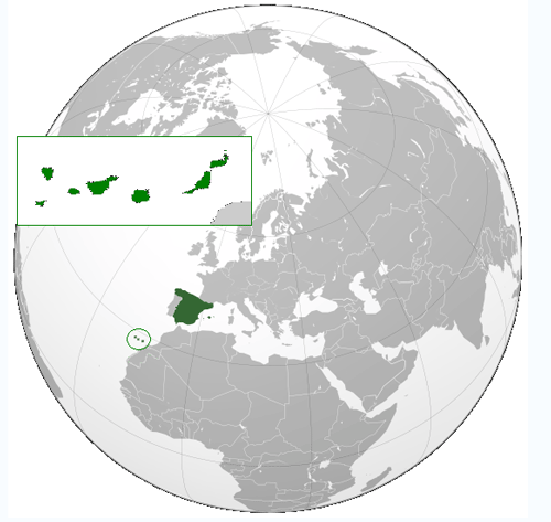
The Canary Islands are situated roughly 1,300 km (800 miles) southwest of mainland Spain and only about 100 km (60 miles) west of the African continent. This unique positioning explains the islands’ year-round mild climate, volcanic landscapes, and cultural blend of European and Atlantic influences.
On a world map, the Canaries appear much closer to Africa than Europe, yet administratively and culturally they function as a Spanish region. This geographic contrast is one of the defining characteristics of the archipelago.
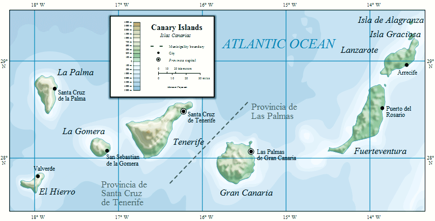
The Seven Main Canary Islands
A standard Canary Islands map typically highlights the seven main inhabited islands, each with its own distinct landscape, tourism profile, and travel rhythm:
- Tenerife – The largest island, home to Mount Teide (Spain’s highest peak) and major international airports.
- Gran Canaria – Known for its diverse microclimates, dunes of Maspalomas, and vibrant capital, Las Palmas.
- Lanzarote – Famous for volcanic terrain, lava fields, and César Manrique–influenced architecture.
- Fuerteventura – Characterized by long beaches, open landscapes, and strong winds ideal for water sports.
- La Palma – Often called “La Isla Bonita,” known for lush forests and volcanic hiking routes.
- La Gomera – A smaller, greener island dominated by Garajonay National Park.
- El Hierro – The westernmost island, known for sustainability initiatives and dramatic scenery.
On most maps, the islands form a gentle east–west chain, with Lanzarote and Fuerteventura lying closest to Africa and La Palma and El Hierro positioned farthest west.
Inter-Island Travel Routes and Ferry Connections
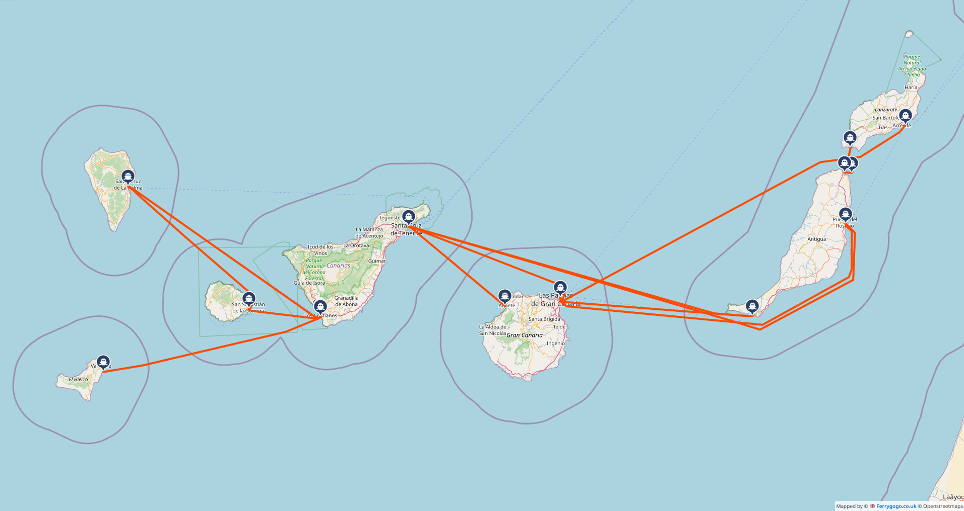
Ferry routes are a key element of Canary Islands maps, especially for travelers planning multi-island itineraries. Regular ferry services connect:
- Tenerife ↔ Gran Canaria (the busiest route)
- Gran Canaria ↔ Fuerteventura
- Fuerteventura ↔ Lanzarote
- Tenerife ↔ La Gomera
- Tenerife ↔ La Palma
- La Gomera ↔ El Hierro
These ferry lines allow both passengers and vehicles, making island-hopping feasible without relying solely on domestic flights. On route maps, ferry paths are often illustrated as curved or dotted lines across the Atlantic between islands.
Typical Island-Hopping Travel Flow
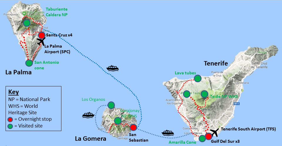
Many travelers use Tenerife or Gran Canaria as their main entry points due to international flight availability. From there, routes often branch out toward smaller western islands such as La Gomera and La Palma, or eastward toward Lanzarote and Fuerteventura.
Maps showing travel flows are especially useful for:
- Planning efficient island-hopping itineraries
- Understanding ferry time distances
- Visualizing logical travel sequences
Political and Administrative Divisions
Administratively, the Canary Islands are divided into two provinces, often marked on detailed political maps:
- Province of Santa Cruz de Tenerife – Tenerife, La Palma, La Gomera, El Hierro
- Province of Las Palmas – Gran Canaria, Lanzarote, Fuerteventura
This division has historical and administrative importance but does not affect travel freedom between islands. Maps that include provincial boundaries help clarify governance rather than tourism logistics.
Why Maps Matter When Exploring the Canary Islands
Because the Canary Islands function as a geographically dispersed destination, maps are essential tools for both first-time visitors and returning travelers. A clear Canary Islands map helps:
- Understand relative island distances
- Compare island sizes and terrain
- Plan transport routes efficiently
- Visualize volcanic landscapes and national parks
Rather than viewing each island in isolation, maps reveal the Canary Islands as an interconnected Atlantic archipelago shaped by volcanism, ocean currents, and centuries of maritime travel.