
ENGLAND · BOURNEMOUTH GUIDE
Bournemouth Map & Neighbourhoods
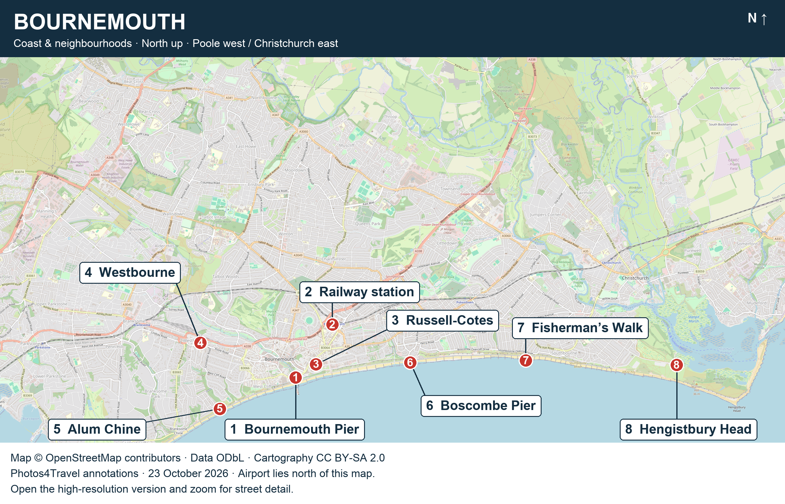
Open the high-resolution Bournemouth map (2622 × 1684 px)
Opens in a new tab. Click the image or use your browser’s zoom controls for street detail.
Bournemouth spreads along the coast, while its railway station and many bus connections sit inland. This map helps you understand the relationship between the central seafront, the western and eastern districts and the approach to Hengistbury Head. It is an orientation map, not a live navigation or step-free route guarantee.
Read the map
On smaller screens, swipe or scroll horizontally to read the full table.
| Number | Place and planning role |
|---|---|
| 1 | Bournemouth Pier — central coastal landmark. |
| 2 | Bournemouth station — inland rail arrival; allow a final journey to the beach or hotel. |
| 3 | Russell-Cotes — East Cliff cultural visit. |
| 4 | Westbourne — independent shopping and dining inland from the western beaches. |
| 5 | Alum Chine — western coastal base and beach approach. |
| 6 | Boscombe Pier — eastern coastal outing. |
| 7 | Fisherman’s Walk — Southbourne coastal approach. |
| 8 | Hengistbury Head visitor centre — starting point for a separate nature outing. |
North is at the top. Poole lies west of this central area and Christchurch lies east. Bournemouth Airport is north of the map’s displayed extent; its absence from this coastal view should not be read as a position beside the station. Use Airports & Transfers for that journey.
Coast and inland streets are different routes
The promenade provides a long coastal connection, but a hotel or restaurant shown near the shore may be on the cliff above it. A short horizontal distance can conceal a climb, steps or a detour to an open access point. Choose the actual route from the accommodation entrance, especially with bags or wheels.
The Square, Lower Gardens and Pier Approach form the most compact central visitor sequence. The station is further inland and east of that sequence. If arriving with luggage, check the current bus stop or taxi arrangement rather than automatically walking the whole way before you have seen the route.
Use the districts to group a day
Keep Westbourne browsing and Alum Chine beach time together when the route and weather suit you. Treat the central gardens, museum and pier as another cluster. Boscombe offers its own pier-and-garden pairing, while Southbourne fits a day oriented around neighbourhood food and the eastern coast.
Hengistbury Head deserves a separate transport and walking plan. Decide whether you are visiting the centre, walking on the headland or continuing toward Mudeford Sandbank. They share a starting area but involve different effort. The itinerary guide turns these geographical groups into practical days.
Check the route before relying on it
Map detail records a point in time. Temporary closures, bus diversions, lift outages and seasonal restrictions can change a route. For accessible travel, use the operator or venue’s current information alongside the map. For an outdoor day, consult weather and local notices before choosing an exposed section.
Travel Tip
For a hotel booking, compare the full walking route to the entrance you intend to use. Straight-line map proximity is a poor substitute for checking the cliff-to-beach approach.
Read Where to Stay for district trade-offs, Getting Around for local journeys and Accessibility for source-based access planning. The map uses OpenStreetMap cartography and geographical data; the numbered annotations were added by Photos4Travel.
Map & Neighbourhoods FAQs
How do I open a readable full-size Bournemouth map?
Use the high-resolution button directly below the map and its credit. It opens the 2622 × 1684 pixel version in a new tab. Your browser may initially fit it to the window; click the image or use the browser’s zoom controls to inspect the original detail.
Why is Bournemouth Airport not marked on this map?
The map covers the town, neighbourhoods and coast; the airport lies north of the displayed area. Use Airports & Transfers to plan that arrival instead of extending the coastal orientation map into an airport route.
Can I use the map to judge whether a route is step-free?
No. It shows the relationship between places, not verified gradients, steps, closures or accessible entrances. A short line between a cliff-top hotel and the promenade may hide a substantial descent. Check a current route and the specific access details before relying on it.