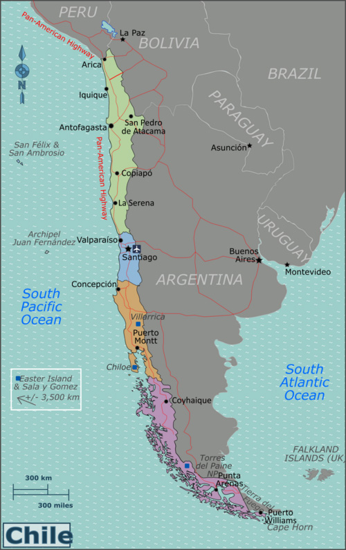
Chile is one of the longest and narrowest countries on Earth, stretching over 4,300 kilometers from north to south — from the arid Atacama Desert to the icy fjords of Patagonia. This Map of Chile helps travelers visualize the country’s remarkable geography, major regions, and key travel routes. Use it to plan your itinerary, discover where to go, and understand the diversity that makes Chile such an extraordinary destination.
Top Highlights
Chile’s elongated shape crosses multiple climates, time zones, and landscapes. The map showcases the main travel regions and their most famous attractions.
- Northern Chile: Atacama Desert, El Tatio Geysers, San Pedro de Atacama, and coastal cities like Arica and Iquique.
- Central Chile: Santiago, Valparaíso, Casablanca Valley, and the Pacific beaches.
- Southern Chile: Lake District, Chiloé Island, and Patagonia with Torres del Paine National Park.
- Isolated Territories: Easter Island (Rapa Nui) and the Juan Fernández Archipelago.

Geographical Overview
Chile lies along South America’s western edge, bordered by Peru to the north, Bolivia and Argentina to the east, and the Pacific Ocean to the west. Its shape is a result of the Andes Mountains running parallel to the coast — a natural wall separating Chile from its neighbors. The country’s extreme length gives rise to one of the most diverse sets of climates on the planet, from desert to glaciers.
- Latitude Range: 17°S to 56°S
- Length: 4,300 km (2,670 miles)
- Average Width: 180 km (112 miles)
- Highest Point: Ojos del Salado (6,893 m)
- Coastline: Over 6,400 km along the Pacific Ocean
Main Regions of Chile
1. Northern Chile
Home to the Atacama Desert, the world’s driest non-polar desert, northern Chile is famous for its salt flats, geysers, and stargazing observatories. San Pedro de Atacama is the main hub for visitors exploring the desert’s surreal landscapes, such as the Valle de la Luna and the Thermal Lake.
2. Central Chile
This is the country’s cultural and political heartland, where Santiago sits surrounded by vineyards and the Andes. The coastal cities of Valparaíso and Viña del Mar offer a mix of art, architecture, and beach life. Nearby, the Casablanca Valley is known for world-class wine and scenic drives.
3. Southern Chile
The Lake District and Patagonia dominate southern Chile, offering volcanoes, waterfalls, forests, and glacier-fed lakes. The iconic Torres del Paine National Park is one of the world’s premier trekking destinations. Ferries and the Carretera Austral connect remote villages and national parks across this dramatic region.
4. Remote Islands
Far off Chile’s coastline lie the mysterious islands that expand its borders into the Pacific. Rapa Nui (Easter Island) is a UNESCO World Heritage Site known for its ancient Moai statues, while the Juan Fernández Islands are rich in marine biodiversity.
Travel Routes & Distances
Chile’s map helps you plan travel efficiently — the country’s length makes it essential to combine flights, long-distance buses, or road trips. Below are some key distances between major destinations:
| Route | Distance (km) | By Flight | By Bus/Car |
|---|---|---|---|
| Santiago → San Pedro de Atacama | 1,630 | 2 hrs | 20 hrs |
| Santiago → Valparaíso | 120 | — | 2 hrs |
| Santiago → Puerto Montt | 1,020 | 1.5 hrs | 12 hrs |
| Punta Arenas → Torres del Paine | 320 | — | 5 hrs |
| Santiago → Easter Island | 3,760 | 5.5 hrs | — |
Natural Wonders on the Map
Chile’s geography offers an unmatched variety of natural attractions visible on the map:
- Atacama Salt Flats (Salar de Atacama): Bright white salt plains dotted with flamingos.
- El Tatio Geysers: One of the world’s highest geyser fields.
- Lake District: Volcano-framed lakes and forests in the south.
- Patagonian Glaciers: Part of the Southern Ice Field, one of the largest in the world.
- Andes Mountains: The backbone of Chile, visible throughout the entire country.
Interactive Travel Planning
Use Chile’s map to build your itinerary strategically:
- Fly between distant regions like Atacama and Patagonia.
- Take scenic road trips in the Carretera Austral or wine valleys.
- Combine urban culture in Santiago with outdoor adventures nearby.
- Explore the coast via bus routes connecting Valparaíso, La Serena, and Iquique.
Where to Go Next
Now that you’ve seen how vast and diverse Chile is, dive deeper into its individual regions:
- About Chile – Learn about the country’s culture and geography.
- Things to Do in Chile – Discover top adventures and landmarks.
- Transportation Guide for Chile – Travel efficiently across distances.
- Beaches in Chile – Explore the Pacific coastline from north to south.
From the deserts of the north to the glaciers of the south, Chile’s map tells the story of a country shaped by nature’s extremes. Every region has its own rhythm, beauty, and adventure waiting to be explored — one line, one curve, one landscape at a time.
